
Product Details

Product Number
534182
Series
SIM-3484
Scale
NO SCALE
Alternate ID
SIM3484
Authors
CHRISTOPHER L RICHMOND
Version Date
01/01/2021
Regions
AK
Countries
USA
Media
Paper
Format
Flat
Digital Reproduction
Yes

Additional Details

Description
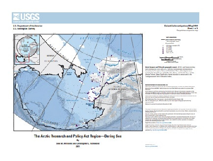
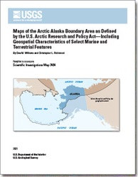
Maps of the Arctic Alaska Boundary Area as Defined by the U.S. Arctic Research and Policy Act—Including Geospatial Characteristics of Select Marine and Terrestrial Features

Scientific Investigations Map 3484

First posted November 30, 2021

For additional information, contact:

Regional Director, Alaska

https://www.usgs.gov/unified-interior-regions/region-11

U.S. Geological Survey

4210 University Drive

Anchorage, Alaska 99508-4560

Abstract

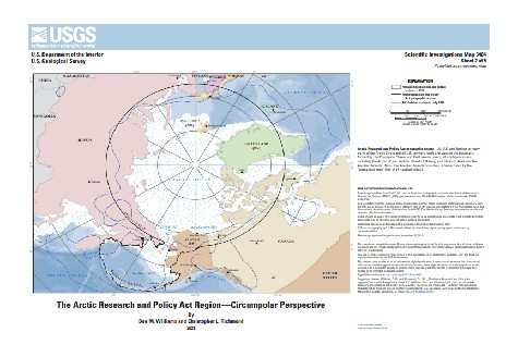
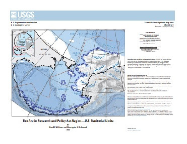
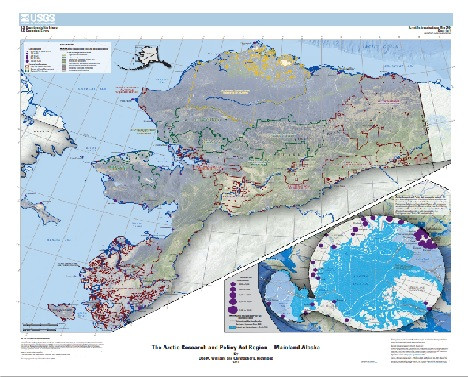
This pamphlet presents a series of general reference maps showing relevant geospatial features of the U.S. Arctic boundary as defined by the U.S. Congress since 1984. The first generation of the U.S. Arctic Research and Policy Act (ARPA) boundary maps was originally formatted and published in 2009 by a private firm contracted with the National Science Foundation and the U.S. Arctic Research Commission. Recognizing the steadily increasing relevance of Arctic issues to national and global affairs that requires more functional projections and online tools, the U.S. Geological Survey (USGS) Alaska Regional Office and the National Geospatial Technical Operations Center developed this updated series of ARPA boundary maps. Map sheet 1 shows the ARPA boundary as it relates to Alaska and marine features of the Bering Sea. Map sheet 2 shows the ARPA boundary from a circumpolar perspective. Map sheet 3 shows the national boundary of the U.S. 200-nautical-mile Exclusive Economic Zone through the Bering, Chukchi, and Beaufort Seas, facilitating Arctic domain awareness and more consistent territorial assessments of the U.S. Arctic. Map sheet 4 shows, in poster-size detail, the ARPA boundary as it relates to terrestrial features of Arctic Alaska north of the Yukon and Kuskokwim Rivers. Map sheet 5 shows, in poster-size detail, the ARPA boundary as it relates to marine and terrestrial features of the Aleutian Islands. These new maps collectively illustrate several value-added attributes, including updated bathymetry and shoreline refinements, demographic information, international borders and offshore territorial claims, Alaska conservation areas, Alaska land cover, Alaska terrestrial shaded relief, annual sea ice maximum extent, annual circumpolar 10-degree-Celsius isotherm, location of active volcanoes, and updated geospatial information. The static PDF-file maps offer value as standalone products but are intended for use with a potential interactive website that can be sourced by annual data updates, allowing users to access the various map layers in a dynamic up-to-date environment.

Survey Date
2021
Print Date
2021
Height In Inches
35.000
Length In Inches
34.000
Two Sided
No
Pieces
6
Languages
English
Related Items
GEOLOGIC MAP SHALBATANA VALLIS, MARS
Geologic Map of the Source Region of Shalbatana Vallis, Mars <p> Scientific Investigations Map 3492 <p> Prepared for the National Aeronautics and Space Administration By: Daniel C. Berman, J. Alexis Palmero Rodriguez, Catherine M. Weitz, and David A. CrownGeologic map of the source region of Shalbatana Vallis, Mars <p> <p> For additional information, contact: <p> Astrogeology Science Center <p> https://www.usgs.gov/centers/astrogeology-science-center <p> U.S. Geological Survey <p> 2255 N. Gemini Dr. <p> Flagstaff, AZ 86001 <p> <p> Abstract <p> <p> Xanthe Terra is a high-standing cratered plain located southeast of Lunae Planum and south of Chryse Planitia in the western equatorial region of Mars. It contains landforms shaped by diverse geologic processes, including various scales of channels and valleys, chaotic terrains, delta fan deposits, and landslides. An extensive outflow channel system is located within Xanthe Terra and the surrounding circum-Chryse region, including Shalbatana and Ravi Valles, thought to have formed by catastrophic flooding during the Hesperian to Amazonian Periods. The study region within Xanthe Terra is defined by Mars Transverse Mercator (MTM) quadrangles 00042 and 00047 (2.5° to -2.5° N, 310° to 320° E) and includes Orson Welles crater (124.5 km diameter, the source region for Shalbatana Vallis), the southernmost portion of Shalbatana Vallis, Aromatum Chaos (the source region for Ravi Vallis), the westernmost portion of Ravi Vallis, and the source area of Nanedi Valles. The Mars Odyssey Thermal Emission Image System (THEMIS) IR daytime mosaic (100 m/pixel) was used as the primary base map. We constructed the geologic map of the source region of Shalbatana Vallis at 1:750,000 scale. We defined 16 geologic units in the map area, which we divided into the following groups: plains units, channel units, crater units, chaos units, flow units, and surficial units. Mapped linear features include ridge crests, scarp crests, channels, crests of crater rims, crests of buried or degraded crater rims, graben traces, grooves, troughs, and faults. Surface features include secondary crater chains and dark ejecta material. The geologic history of the map region can be summarized as follows. During the Noachian Period, ancient highland materials in the Xanthe Terra region, including lava and any ancient sedimentary units present, were reworked by impacts during the heavy bombardment. In particular, the impact that formed a basin that later underwent widespread resurfacing, likely as a combination of lava flows, reworked crater materials, and sedimentary deposits resulting in the flat-lying, smooth plains of Chryse Planitia. The Hesperian Period was characterized by the impact that formed Orson Welles crater and the subsequent formation of Shalbatana Vallis, as well as Aromatum Chaos and Ravi Vallis. During this period, depressions were filled with smooth material that was subsequently modified by collapse, subsidence, and flooding. Water filled and overflowed the tops of Orson Welles crater and other depressions. The Amazonian Period was characterized by ongoing collapse, as well as the formation of flow and surficial materials, including a lava flow that extends from Aromatum Chaos. <p>
GEOLOGIC MAP MORAVA VALLES BASIN, MARS
<p> Geologic Map of MTM -10022 and -15022 Quadrangles, Morava Valles and Margaritifer Basin, Mars <p> <p> First posted August 15, 2022 <p> For additional information, contact: Contact Astrogeology Research Program staff Astrogeology Science Center U.S. Geological Survey 2255 N. Gemini Dr. Flagstaff, AZ 86001 <p> <p> <p> Abstract <p> <p> The landscape in Mars Transverse Mercator (MTM) -10022 and -15022 quadrangles (lat -7.5° N. to -17.5° N. between long 335° E. and 340° E.) in Margaritifer Terra preserves a record of sedimentary and alluvial deposits, volcanic and tectonic structures, and erosional landforms that record a long and complex geologic and geomorphic history. MTM -10022 and -15022 quadrangles primarily encompass Morava Valles, the terminus of the Samara-Himera and Paraná-Loire valley networks, the broad catchment informally named Margaritifer basin, and Margaritifer Chaos. Morava Valles is the lowermost reach of the northward draining mesoscale outflow system that consists of Uzboi Vallis, Ladon Valles, and Morava Valles, was sourced from flow out of Argyre basin, and incises across and between the ancient Ladon and Holden impact basins. The broad-scale topography and surface relief within the map, including the topographic low occupied by Margaritifer basin, were largely shaped during the Noachian by the formation of the Holden, Ladon, and Ares impact basins and the Chryse trough. Multiple processes modified the ancient surface until the Late Noachian and resulted in the formation of the terra unit that forms the widely exposed surface. Later resurfacing associated with likely sedimentary and volcanic processes modified predominantly lower elevation surfaces and basins during the Late Noachian into at least the Hesperian. Sedimentary processes during the Late Noachian were dominated by fluvial incision of the Samara-Himera and Paraná-Loire valley networks and discharge related to the dissection of Morava Valles that drained Ladon basin. The history of geomorphic activity within Margaritifer basin was more complex and was likely dominated by the evolution of Morava Valles relative to the formation of the valley networks. The floor of Margaritifer basin preserves likely lacustrine plains related to sedimentation in water ponded during early discharge from Morava Valles, which were later embayed by volcanic plains. Crater densities and cross-cutting relations indicate Margaritifer basin evolved over a relatively short period of geologic time. The timing of the last drainage out of Morava Valles is not well constrained but could have occurred during the Hesperian. Structural collapse and the formation of the Margaritifer Chaos and other chaotic terrain formed by the release of subsurface water that may have been related to volcanic activity along the southern margin of Margaritifer basin. Final geomorphic events within the map region include the formation of Late Hesperian to perhaps Amazonian alluvial fans within some craters and isolated mass wasting on steep slopes. A final, variable veneer associated with locally occurring impacts and redistribution of fine-grained material by eolian processes resulted in the landscape observed today. <p>
MARINE MINERALS IN ALASKA A REVIEW OF
<p> Marine minerals in Alaska — A review of coastal and deep-ocean regions <p> <p> First posted July 14, 2022 <p> For additional information, contact: Pacific Coastal and Marine Science Center U.S. Geological Survey 2885 Mission St. Santa Cruz, CA 95060 <p> <p> Abstract <p> <p> Minerals occurring in marine environments span the globe and encompass a broad range of mineral categories, forming within varied geologic and oceanographic settings. They occur in coastal regions, either from the continuation or mechanical reworking of terrestrial mineralization, as well as in the deep ocean, from diagenetic, hydrogenetic, and hydrothermal processes. The oceans cover most of the Earth’s surface and as a result, any inventory of global resources is incomplete without the inclusion of marine minerals. This study by the U.S. Geological Survey reviews current knowledge regarding deep-ocean and coastal marine minerals within the marine areas surrounding Alaska, including the Alaska Outer Continental Shelf (OCS). For the purposes of this study, we have divided these areas in to eight regions: (1) Gulf of Alaska seamounts, (2) Chukchi Borderland, (3) Canada Basin, (4) Aleutian Arc, (5) Seward Peninsula, (6) Goodnews Bay, (7) Bristol Bay and Alaska Peninsula, and (8) southern and southeastern Alaska. The Alaska OCS encompasses several areas broadly conducive to marine mineral formation, including extensional basins resulting from an active subduction zone where massive sulfide deposits may form, deep abyssal plains with conditions that may lead to manganese nodule formation, seamounts that can provide substrate for the growth of ferromanganese crusts, and erosional settings and submerged continental crust where placer deposits are found. For deep-ocean hydrothermal minerals and manganese nodules, the Alaska OCS contains prospective regions, including the Canada Basin and the Aleutian Arc; however, no such minerals have yet been identified. We explore the probability that these minerals occur based on reviews of existing geologic and oceanographic data within the relevant sections. In regions far from shore data are limited. Deep-ocean ferromanganese crusts are known to occur in two regions: (1) the Gulf of Alaska seamounts and (2) the Chukchi Borderland in the Arctic Ocean. Limited sampling has occurred in both regions, and along the Chukchi Borderland the sampling was outside of the OCS and the U.S. Exclusive Economic Zone. Data relevant to coastal minerals is more extensive, and in some places fairly systematic sampling was conducted. Several nearshore placer deposits have been exploited for decades; however, the potential for nearshore extension of terrestrial ore deposits is less well considered. This contribution considers the state of knowledge regarding marine mineral occurrences within the Alaska regions and identifies the data gaps in order to help inform future marine mineral related research efforts around Alaska. <p>