GEOLOGIC MAP SHALBATANA VALLIS, MARS

Product Details
- Product Number
- 534113
- Series
- SIM-3492
- Scale
- 1:750,000
- Alternate ID
- SIM3492
- ISBN
- 978-1-4113-4476-1
- Authors
- C M WEITZ
- Version Date
- 01/01/2022
- Media
- Paper
- Format
- Folded
Additional Details
- Description
-
Geologic Map of the Source Region of Shalbatana Vallis, Mars
Scientific Investigations Map 3492
Prepared for the National Aeronautics and Space Administration By: Daniel C. Berman, J. Alexis Palmero Rodriguez, Catherine M. Weitz, and David A. CrownGeologic map of the source region of Shalbatana Vallis, Mars
For additional information, contact:
Astrogeology Science Center
https://www.usgs.gov/centers/astrogeology-science-center
U.S. Geological Survey
2255 N. Gemini Dr.
Flagstaff, AZ 86001
Abstract
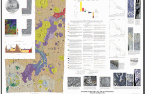
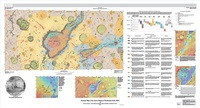
Xanthe Terra is a high-standing cratered plain located southeast of Lunae Planum and south of Chryse Planitia in the western equatorial region of Mars. It contains landforms shaped by diverse geologic processes, including various scales of channels and valleys, chaotic terrains, delta fan deposits, and landslides. An extensive outflow channel system is located within Xanthe Terra and the surrounding circum-Chryse region, including Shalbatana and Ravi Valles, thought to have formed by catastrophic flooding during the Hesperian to Amazonian Periods. The study region within Xanthe Terra is defined by Mars Transverse Mercator (MTM) quadrangles 00042 and 00047 (2.5° to -2.5° N, 310° to 320° E) and includes Orson Welles crater (124.5 km diameter, the source region for Shalbatana Vallis), the southernmost portion of Shalbatana Vallis, Aromatum Chaos (the source region for Ravi Vallis), the westernmost portion of Ravi Vallis, and the source area of Nanedi Valles. The Mars Odyssey Thermal Emission Image System (THEMIS) IR daytime mosaic (100 m/pixel) was used as the primary base map. We constructed the geologic map of the source region of Shalbatana Vallis at 1:750,000 scale. We defined 16 geologic units in the map area, which we divided into the following groups: plains units, channel units, crater units, chaos units, flow units, and surficial units. Mapped linear features include ridge crests, scarp crests, channels, crests of crater rims, crests of buried or degraded crater rims, graben traces, grooves, troughs, and faults. Surface features include secondary crater chains and dark ejecta material. The geologic history of the map region can be summarized as follows. During the Noachian Period, ancient highland materials in the Xanthe Terra region, including lava and any ancient sedimentary units present, were reworked by impacts during the heavy bombardment. In particular, the impact that formed a basin that later underwent widespread resurfacing, likely as a combination of lava flows, reworked crater materials, and sedimentary deposits resulting in the flat-lying, smooth plains of Chryse Planitia. The Hesperian Period was characterized by the impact that formed Orson Welles crater and the subsequent formation of Shalbatana Vallis, as well as Aromatum Chaos and Ravi Vallis. During this period, depressions were filled with smooth material that was subsequently modified by collapse, subsidence, and flooding. Water filled and overflowed the tops of Orson Welles crater and other depressions. The Amazonian Period was characterized by ongoing collapse, as well as the formation of flow and surficial materials, including a lava flow that extends from Aromatum Chaos.
- Two Sided
- No
- Pieces
- 1
- Languages
- English