Product
Product

GEOLOGIC MAP MORAVA VALLES BASIN, MARS

$9.00
Available

Product Details

Product Number
534128
Series
SIM-3489
Scale
1:500,000
Alternate ID
SIM3489
ISBN
978-1-4113-4478-5
Authors
JOHN A GRANT
Version Date
01/01/2022
Media
Paper
Format
Folded

Additional Details

Description

Geologic Map of MTM -10022 and -15022 Quadrangles, Morava Valles and Margaritifer Basin, Mars

First posted August 15, 2022

For additional information, contact: Contact Astrogeology Research Program staff Astrogeology Science Center U.S. Geological Survey 2255 N. Gemini Dr. Flagstaff, AZ 86001

Abstract

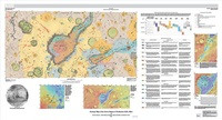
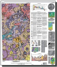
The landscape in Mars Transverse Mercator (MTM) -10022 and -15022 quadrangles (lat -7.5° N. to -17.5° N. between long 335° E. and 340° E.) in Margaritifer Terra preserves a record of sedimentary and alluvial deposits, volcanic and tectonic structures, and erosional landforms that record a long and complex geologic and geomorphic history. MTM -10022 and -15022 quadrangles primarily encompass Morava Valles, the terminus of the Samara-Himera and Paraná-Loire valley networks, the broad catchment informally named Margaritifer basin, and Margaritifer Chaos. Morava Valles is the lowermost reach of the northward draining mesoscale outflow system that consists of Uzboi Vallis, Ladon Valles, and Morava Valles, was sourced from flow out of Argyre basin, and incises across and between the ancient Ladon and Holden impact basins. The broad-scale topography and surface relief within the map, including the topographic low occupied by Margaritifer basin, were largely shaped during the Noachian by the formation of the Holden, Ladon, and Ares impact basins and the Chryse trough. Multiple processes modified the ancient surface until the Late Noachian and resulted in the formation of the terra unit that forms the widely exposed surface. Later resurfacing associated with likely sedimentary and volcanic processes modified predominantly lower elevation surfaces and basins during the Late Noachian into at least the Hesperian. Sedimentary processes during the Late Noachian were dominated by fluvial incision of the Samara-Himera and Paraná-Loire valley networks and discharge related to the dissection of Morava Valles that drained Ladon basin. The history of geomorphic activity within Margaritifer basin was more complex and was likely dominated by the evolution of Morava Valles relative to the formation of the valley networks. The floor of Margaritifer basin preserves likely lacustrine plains related to sedimentation in water ponded during early discharge from Morava Valles, which were later embayed by volcanic plains. Crater densities and cross-cutting relations indicate Margaritifer basin evolved over a relatively short period of geologic time. The timing of the last drainage out of Morava Valles is not well constrained but could have occurred during the Hesperian. Structural collapse and the formation of the Margaritifer Chaos and other chaotic terrain formed by the release of subsurface water that may have been related to volcanic activity along the southern margin of Margaritifer basin. Final geomorphic events within the map region include the formation of Late Hesperian to perhaps Amazonian alluvial fans within some craters and isolated mass wasting on steep slopes. A final, variable veneer associated with locally occurring impacts and redistribution of fine-grained material by eolian processes resulted in the landscape observed today.

Height In Inches
54.010
Length In Inches
45.730
Two Sided
No
Pieces
1
Languages
English
Related Items
GEOLOGIC MAP SHALBATANA VALLIS, MARS
Geologic Map of the Source Region of Shalbatana Vallis, Mars <p> Scientific Investigations Map 3492 <p> Prepared for the National Aeronautics and Space Administration By: Daniel C. Berman, J. Alexis Palmero Rodriguez, Catherine M. Weitz, and David A. CrownGeologic map of the source region of Shalbatana Vallis, Mars <p> <p> For additional information, contact: <p> Astrogeology Science Center <p> https://www.usgs.gov/centers/astrogeology-science-center <p> U.S. Geological Survey <p> 2255 N. Gemini Dr. <p> Flagstaff, AZ 86001 <p> <p> Abstract <p> <p> Xanthe Terra is a high-standing cratered plain located southeast of Lunae Planum and south of Chryse Planitia in the western equatorial region of Mars. It contains landforms shaped by diverse geologic processes, including various scales of channels and valleys, chaotic terrains, delta fan deposits, and landslides. An extensive outflow channel system is located within Xanthe Terra and the surrounding circum-Chryse region, including Shalbatana and Ravi Valles, thought to have formed by catastrophic flooding during the Hesperian to Amazonian Periods. The study region within Xanthe Terra is defined by Mars Transverse Mercator (MTM) quadrangles 00042 and 00047 (2.5° to -2.5° N, 310° to 320° E) and includes Orson Welles crater (124.5 km diameter, the source region for Shalbatana Vallis), the southernmost portion of Shalbatana Vallis, Aromatum Chaos (the source region for Ravi Vallis), the westernmost portion of Ravi Vallis, and the source area of Nanedi Valles. The Mars Odyssey Thermal Emission Image System (THEMIS) IR daytime mosaic (100 m/pixel) was used as the primary base map. We constructed the geologic map of the source region of Shalbatana Vallis at 1:750,000 scale. We defined 16 geologic units in the map area, which we divided into the following groups: plains units, channel units, crater units, chaos units, flow units, and surficial units. Mapped linear features include ridge crests, scarp crests, channels, crests of crater rims, crests of buried or degraded crater rims, graben traces, grooves, troughs, and faults. Surface features include secondary crater chains and dark ejecta material. The geologic history of the map region can be summarized as follows. During the Noachian Period, ancient highland materials in the Xanthe Terra region, including lava and any ancient sedimentary units present, were reworked by impacts during the heavy bombardment. In particular, the impact that formed a basin that later underwent widespread resurfacing, likely as a combination of lava flows, reworked crater materials, and sedimentary deposits resulting in the flat-lying, smooth plains of Chryse Planitia. The Hesperian Period was characterized by the impact that formed Orson Welles crater and the subsequent formation of Shalbatana Vallis, as well as Aromatum Chaos and Ravi Vallis. During this period, depressions were filled with smooth material that was subsequently modified by collapse, subsidence, and flooding. Water filled and overflowed the tops of Orson Welles crater and other depressions. The Amazonian Period was characterized by ongoing collapse, as well as the formation of flow and surficial materials, including a lava flow that extends from Aromatum Chaos. <p>
EROSION IN NAVAJO MINE AREA, NM
Map of erosion potential and sediment sources in the Navajo Mine area, San Juan County, New Mexico <p> Miscellaneous Field Studies Map 1432 <p> By: David L. Weide <p> https://doi.org/10.3133/mf1432 <p> <p> Abstract <p> <p> This map shows estimated erosion and sediment yields of an area designated for extensive surface mining, in San Juan County, New Mexico. The results of this study are important for the planning of future mining operations and will aid in developing suitable reclamation procedures. In addition, these data will serve as a base line from which a long-term program for determining rates of erosion and deposition could be developed. Such measurements are essential to understanding the impact of surface mining on geomorphic processes affected by extraction of resources form arid lands. The area chosen for the study lies within for 7-1/2-minute quadrangles (The Hogback South, Kirtland SW, Newcomb NE, and The Pillar NW) in the northwest San Juan Basin (figs. 1,2). The area includes five drainage basins covering approximately 200 mi2 (520 km2) that flow west into the Chaco River (fig. 1). Approximately 41 mi2 (106 km2) of this area is scheduled for surface mining during the next several years as part of the southern extension of the Navajo Mine. <p>
BENTHIC ALGAE IN UPPER WHITE RIVER BASIN
Potential Factors Controlling Benthic Algae in the Upper White River Basin, Colorado, 2018–21 <p> Fact Sheet 2023-3005 <p> Prepared in cooperation with White River and Douglas Creek Conservation Districts, Colorado River Salinity Control Forum, Colorado River Water Conservation District <p> By: Rachel G. Gidley and Natalie K. Day <p> <p> </p> <font color=red> <p> This product is not available for order, it can only be downloaded from here (click on image) or within the Publications Warehouse at https://pubs.er.usgs.gov/publication/fs20233005 </p> </i> </font> <p> <p> For additional information, contact: <p> Director, Colorado Water Science Center <p> https://www.usgs.gov/centers/colorado-water-science-center/ <p> <p> U.S. Geological Survey <p> Box 25046, Mail Stop 415 <p> Denver, CO 80225 <p> <p> Abstract <p> <p> Nuisance levels of benthic algae are becoming increasingly common in surface waters of the western United States and can compromise aesthetic quality, limit recreational activities, block water infrastructure, and negatively affect aquatic life. In cooperation with the White River and Douglas Creek Conservation Districts, the Colorado River Basin Salinity Control Forum, and the Colorado River Water Conservation District, the U.S. Geological Survey studied physical, chemical, and biological factors potentially controlling the occurrence of benthic algae in the upper White River Basin, Colorado, from 2018 through 2021. Multiple approaches were used to assess nutrients and physical conditions in the upper White River Basin. A linear mixed-effects model was used to evaluate the relative effect of different factors on algal biomass across water-quality sites. <p> <p> The frequency and severity of algal blooms in the upper White River Basin may be affected by long-term changes in nutrient availability and streamflow, specifically changes in the timing and magnitude of high and low streamflow. The effects of large peak streamflow, including movement of the streambed, may be the dominant control on the occurrence of algal blooms through years. Large, late, and long-lasting peak streamflow may limit algal blooms during the same year and into subsequent years. Without streambed disturbance, other factors such as nutrients and water temperature may have a larger effect on algal biomass. <p>