Product

EROSION IN NAVAJO MINE AREA, NM

$9.00
Available

Product Details

Product Number
30755
Series
MF-1432
Scale
1:50,000
Alternate ID
GMF1432D
ISBN
978-0-607-81091-2
Authors
WEIDE, D. L.
Version Date
01/01/1982
Regions
NM
Countries
USA
Media
Paper
Format
Flat
Digital Reproduction
Yes

Additional Details

Description
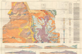
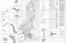
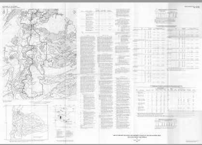
Map of erosion potential and sediment sources in the Navajo Mine area, San Juan County, New Mexico

Miscellaneous Field Studies Map 1432

By: David L. Weide

https://doi.org/10.3133/mf1432

Abstract

This map shows estimated erosion and sediment yields of an area designated for extensive surface mining, in San Juan County, New Mexico. The results of this study are important for the planning of future mining operations and will aid in developing suitable reclamation procedures. In addition, these data will serve as a base line from which a long-term program for determining rates of erosion and deposition could be developed. Such measurements are essential to understanding the impact of surface mining on geomorphic processes affected by extraction of resources form arid lands. The area chosen for the study lies within for 7-1/2-minute quadrangles (The Hogback South, Kirtland SW, Newcomb NE, and The Pillar NW) in the northwest San Juan Basin (figs. 1,2). The area includes five drainage basins covering approximately 200 mi2 (520 km2) that flow west into the Chaco River (fig. 1). Approximately 41 mi2 (106 km2) of this area is scheduled for surface mining during the next several years as part of the southern extension of the Navajo Mine.

Survey Date
1982
Print Date
1982
Height In Inches
34.100
Length In Inches
48.930
Boundary Type
Quadrangle
Two Sided
No
Pieces
1
Languages
English
Related Items
LAKE CITY AREA, MINE MAPS OF, CO
Mine maps of silver-lead-zinc epithermal deposits in the Lake City area, Hindale County, San Juan Mountains, Colorado
TENNESSEE PASS AREA, CO
Geologic map of the Tennessee Pass area, Eagle and Lake counties, Colorado <p> <p> Miscellaneous Field Studies Map 34 <p> By: Ogden Tweto <p> <p> https://doi.org/10.3133/mf34 <p> <p> Abstract <p> <p> The triangular area bounded by the most productive mining districts of central Colorado- Leadville, Climax-Kokomo, and Gilman-Red Cliff- is of economic interest not only because of its close spatial relation to these districts but because it is closely related geologically. It contains the same rocks as the adjoining mining districts and is closely related to them structurally. It shows widespread evidence of weak mineralization at the surface and may contain ore deposits at depth, as the zones that have been productive in the adjoining mining districts lie beneath a cover of younger rocks in much of the area. <p>
MINE & PROSP MAP MANZANO WILDE, NM
Mine and prospect map of the Manzano Wilderness, Torrance and Valencia counties, New Mexico <p> Miscellaneous Field Studies Map 1464-D <p> By: Thomas D. Light <p> https://doi.org/10.3133/mf1464D <p> <p> Abstract <p> <p> The U.S. Geological Survey and the U.S. Bureau of Mines conducted field investigations to evaluate the mineral resources of the Manzano Wilderness, Torrance and Valencia Counties, N. Mex., during 1980 and 1982. This map complements the mineral resource appraisal of the Manzano Wilderness (Maxwell and others, 1983). Field studies by the Bureau of Mines included a reconnaissance of mines, prospects, and mineralized areas. From workings within and near the wilderness, 107 samples were taken and analyzed. <p>