Product Details
- Product Number
- 342722
- Series
- SIM-3194
- Scale
- 1:24,000
- Alternate ID
- SIM3194
- Authors
- SCOTT A MINOR
- Version Date
- 01/01/2011
- Regions
- NM
- Countries
- USA
- Media
- Paper
- Format
- Flat
- Digital Reproduction
- Yes
Additional Details
- Description
-
Abstract
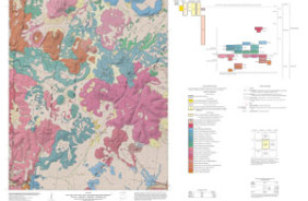
The Cochiti Dam quadrangle is located in the southern part of the Española Basin and contains sedimentary and volcanic deposits that record alluvial, colluvial, eolian, tectonic and volcanic processes over the past seventeen million years. The geology was mapped from 1997 to 1999 and modified in 2004 to 2008. The primary mapping responsibilities were as follows: Dethier mapped the surficial deposits, basin-fill sedimentary deposits, Miocene to Quaternary volcanic deposits of the Jemez volcanic field, and a preliminary version of fault distribution. Thompson and Hudson mapped the Pliocene and Quaternary volcanic deposits of the Cerros del Rio volcanic field. Thompson, Minor, and Hudson mapped surface exposures of faults and Hudson conducted paleomagnetic studies for stratigraphic correlations. Thompson prepared the digital compilation of the geologic map.
The mapped distribution of units is based primarily on interpretation of 1:16,000-scale, color aerial photographs taken in 1992, and 1:40 ,000-scale, black-and-white, aerial photographs taken in 1996. Most of the contacts on the map were transferred from the aerial photographs using a photogrammetric stereo-plotter and subsequently field checked for accuracy and revised based on field determination of allostratigraphic and lithostratigraphic units. Determination of lithostratigraphic units in volcanic deposits was aided by geochemical data, 40Ar/39Ar geochronology, aeromagnetic and paleomagnetic data. Supplemental revision of mapped contacts was based on interpretation of USGS 1-meter orthoimagery.
- Height In Inches
- 42.000
- Length In Inches
- 58.000
- Two Sided
- No
- Pieces
- 1
- Languages
- English