

GEOLOGIC MAP CHICKASAW NATIONAL REC, OK

Product Details
- Product Number
- 391892
- Series
- SIM-3258
- Scale
- 1:24,000
- Alternate ID
- SIM3258
- ISBN
- 978-1-4113-3783-1
- Authors
- CHARLES D BLOME
- Version Date
- 01/01/2013
- Regions
- OK
- Countries
- USA
- Media
- Paper
- Format
- Folded
Additional Details
- Description
-
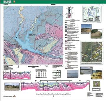
Abstract
This 1:24,000-scale geologic map is a compilation of previous geologic maps and new geologic mapping of areas in and around Chickasaw National Recreation Area. The geologic map includes revisions of numerous unit contacts and faults and a number of previously “undifferentiated” rock units were subdivided in some areas. Numerous circular-shaped hills in and around Chickasaw National Recreation Area are probably the result of karst-related collapse and may represent the erosional remnants of large, exhumed sinkholes.
Geospatial registration of existing, smaller scale (1:72,000- and 1:100 ,000-scale) geologic maps of the area and construction of an accurate Geographic Information System (GIS) database preceded 2 years of fieldwork wherein previously mapped geology (unit contacts and faults) was verified and new geologic mapping was carried out. The geologic map of Chickasaw National Recreation Area and this pamphlet include information pertaining to how the geologic units and structural features in the map area relate to the formation of the northern Arbuckle Mountains and its Arbuckle-Simpson aquifer. The development of an accurate geospatial GIS database and the use of a handheld computer in the field greatly increased both the accuracy and efficiency in producing the 1:24,000-scale geologic map.
- Survey Date
- 2013
- Print Date
- 2013
- Height In Inches
- 40.000
- Length In Inches
- 42.000
- Two Sided
- No
- Pieces
- 2
- Languages
- English


