

GEOLOGIC MAP MONTOSO PEAK QUADRANGLE, NM

Product Details
- Product Number
- 315007
- Series
- SIM-3179
- Scale
- 1:24,000
- Alternate ID
- SIM3179
- Authors
- DAVID A SAWYER
- Version Date
- 01/01/2011
- Regions
- NM
- Countries
- USA
- Media
- Paper
- Format
- Flat
- Digital Reproduction
- Yes
Additional Details
- Description
-
Abstract
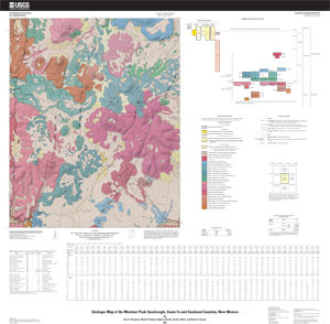
The Montoso Peak quadrangle is underlain by volcanic rocks and associated sediments of the Cerros del Rio volcanic field in the southern part of the Española Basin that record volcanic, faulting, alluvial, colluvial, and eolian processes over the past three million years. The geology was mapped from 1997 to 1999 and modified in 2004 to 2008. The geologic mapping was carried out in support of the U.S. Geological Survey (USGS) Rio Grande Basin Project, funded by the USGS National Cooperative Geologic mapping Program.
The mapped distribution of units is based primarily on interpretation of 1:16,000-scale, color aerial photographs taken in 1992, and 1:40 ,000-scale, black-and-white, aerial photographs taken in 1996. Most of the contacts on the map were transferred from the aerial photographs using a photogrammetric stereoplotter and subsequently field checked for accuracy and revised based on field determination of allostratigraphic and lithostratigraphic units. Determination of lithostratigraphic units in volcanic deposits was aided by geochemical data, 40Ar/39Ar geochronology, aeromagnetic and paleomagnetic data. Supplemental revision of mapped contacts was based on interpretation of USGS 1-meter orthoimagery. This version of the Montoso Peak quadrangle geologic map uses a traditional USGS topographic base overlain on a shaded relief base generated from 10-m digital elevation model (DEM) data from the USGS National Elevation Dataset (NED).
Faults are identified with varying confidence levels in the map area. Recognizing and mapping faults developed near the surface in young, brittle volcanic rocks is difficult because (1) they tend to form fractured zones tens of meters wide rather than discrete fault planes, (2) the youth of the deposits has allowed only modest displacements to accumulate for most faults, and (3) many may have significant strike-slip components that do not result in large vertical offsets that are readily apparent in offset of sub-horizontal contacts. Those faults characterized as “certain” either have distinct offset of map units or had slip planes that were directly observed in the field. Faults classed as “inferred” were traced based on linear alignments of geologic, topographic and aerial photo features such as vents, lava flow edges, and drainages inferred to preferentially develop on fractured rock. Lineaments defined from magnetic anomalies form an additional constraint on potential fault locations.
- Survey Date
- 1993
- Height In Inches
- 36.000
- Length In Inches
- 36.000
- Boundary Type
- Quadrangle
- Two Sided
- No
- Pieces
- 2
- Languages
- English


