


Product Details
- Product Number
- 206267
- Series
- SIM-2903
- Scale
- 1:12,000
- Alternate ID
- SIM2903
- Authors
- DEREK B BOOTH
- Version Date
- 01/01/2006
- Regions
- WA
- Countries
- USA
- Media
- Paper
- Digital Reproduction
- Yes
Additional Details
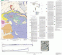
- Description
- This map is the first of four new geologic maps covering the city of Seattle that are based on field exposures and an extensive database of subsurface geologic explorations. The landforms and near-surface deposits here record a relatively brief, recent period in the geologic history of the region that was dominated by the last advance of the continental ice sheet that covered the region about 17,000 years ago. Beneath the deposits of this ice sheet is a complex succession of older sediments that extends far below sea level across most of the map area. These older sediments are now exposed where modern erosion and landslides have sliced through the edge of the upland, most notably in coastal bluffs along Puget Sound.
- Print Date
- 2005
- Height In Inches
- 50.000
- Length In Inches
- 36.000
- Boundary Type
- Political Unit
- Two Sided
- No
- Pieces
- 1
- Languages
- English
Related Items

GEOLOGIC MAP OF THE OLALLA 7.5' QUADRANGLE, KING, KITSAP, AND PIERCE COUNTIES, WASHINGTON

GEOLOGIC MAP OF THE LACAMAS CREEK QUADRANGLE, CLARK COUNTY, WASHINGTON