
GEOLOGIC MAP OF THE YACOLT QUAD, WA
$18.00
Available

Product Details
- Product Number
- 206568
- Series
- SIM-2901
- Scale
- 1:24,000
- Alternate ID
- SIM2901
- Authors
- R C EVARTS
- Version Date
- 08/03/2006
- Regions
- WA
- Countries
- USA
- Media
- Paper
- Format
- Flat
- Digital Reproduction
- Yes
Additional Details
- Description
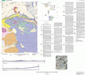
- The Yacolt 7.5' quadrangle is situated in the foothills of the western Cascade Range of southwestern Washington approximately 35 km northeast of Portland, Oregon. Since late Eocene time, the Cascade Range has been the locus of an active volcanic arc associated with underthrusting of oceanic lithosphere beneath the North American continent along the Cascadia Subduction Zone. Volcanic and shallow-level intrusive rocks emplaced early in the history of the arc underlie most of the Yacolt quadrangle, forming a dissected and partly glaciated terrain with elevations between 250 and 2180 ft (75 and 665 m). The bedrock surface slopes irregularly but steeply to the southwest, forming the eastern margin of the Portland Basin, and weakly consolidated Miocene and younger basin-fill sediments lap up against the bedrock terrain in the southern part of the map area. A deep canyon, carved by the East Fork Lewis River that flows westward out of the Cascade Range, separates Yacolt and Bells Mountains, the two highest points in the quadrangle. Just west of the quadrangle, the river departs from its narrow bedrock channel and enters a wide alluvial floodplain.
- Survey Date
- 2003
- Height In Inches
- 36.000
- Length In Inches
- 40.000
- Two Sided
- Yes
- Pieces
- 2
- Languages
- English
Related Items

GEOLOGIC MAP OF THE LACAMAS CREEK QUADRANGLE, CLARK COUNTY, WASHINGTON

Geologic Map of the Amboy Quadrangle, Clark and Cowlitz Counties, Washington

Geologic Map of the Ridgefield Quadrangle, Clark and Cowlitz Counties, Washington