

GEOLOGIC MAP LACAMAS CREEK QUAD, WA
$18.00
Available

Product Details
- Product Number
- 206583
- Series
- SIM-2924
- Scale
- 1:24,000
- Alternate ID
- SIM2924
- Authors
- R.C.EVARTS
- Version Date
- 01/01/2006
- Regions
- WA
- Countries
- USA
- Media
- Paper
- Format
- Flat
- Digital Reproduction
- Yes
Additional Details
- Description
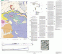
- The Lacamas Creek 7.5' quadrangle is in southwestern Washington, approximately 25 km northeast of Portland, Oregon, along the eastern margin of the Portland Basin, which is part of the Puget-Willamette Lowland that separates the Cascade Range from the Oregon Coast Range. Since late Eocene time, the Cascade Range has been the locus of an episodically active volcanic arc associated with underthrusting of oceanic lithosphere beneath the North American continent along the Cascadia Subduction Zone. Lava flows that erupted early in the history of the arc underlie the eastern half of the Lacamas Creek quadrangle, forming a dissected terrain, with elevations as high as 2050 ft (625 m), that slopes irregularly but steeply to the southwest. These basalt and basaltic andesite flows erupted in early Oligocene time from one or more vents located outside the map area. The flows dip gently (less than 5°) west to southwest. In the western part of the map area, volcanic bedrock is unconformably overlain by middle Miocene to early Pleistocene(?) sediments that accumulated as the Portland Basin subsided. These sediments consist mostly of detritus carried into the Portland Basin by the ancestral Columbia River. Northwest-striking faults offset the Paleogene basin floor as well as the lower part of the basin fill. In middle Pleistocene time, basalt and basaltic andesite erupted from three small volcanoes in the southern half of the map area. These vents are in the northern part of the Boring volcanic field, which comprises several dozen late Pliocene and younger monogenetic volcanoes scattered throughout the greater Portland region. In latest Pleistocene time, the Missoula floods of glacial-outburst origin inundated the Portland Basin. The floods deposited poorly sorted gravels in the southwestern part of the Lacamas Creek quadrangle that grade northward into finer grained sediments. This map is a contribution to a program designed to improve geologic knowledge of the Portland Basin region of the Pacific Northwest urban corridor, the densely populated Cascadia forearc region of western Washington and Oregon. More detailed information on the bedrock and surficial geology of the basin and its surrounding area is necessary to refine assessments of seismic risk, ground-failure hazards and resource availability in this rapidly growing region.
- Survey Date
- 2006
- Height In Inches
- 36.500
- Length In Inches
- 32.000
- Pieces
- 2
- Languages
- English
Related Items

Geologic Map of the Amboy Quadrangle, Clark and Cowlitz Counties, Washington

Geologic Map of the Ridgefield Quadrangle, Clark and Cowlitz Counties, Washington