

Product Details
- Product Number
- 206579
- Series
- SIM-2902
- Scale
- 1:24,000
- Alternate ID
- SIM2902
- Authors
- KATHY GOETZ TROOST
- Version Date
- 01/01/2005
- Regions
- WA
- Countries
- USA
- Media
- Paper
- Format
- Flat
- Digital Reproduction
- Yes
Additional Details
- Description
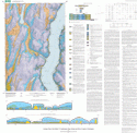
- This quadrangle, which lies almost exactly in the center of the Puget Lowland, displays the broad range of geologic environments typical of the region. The upland plain is fluted by the passage of the great continental ice sheet that last covered the area about 17,000 years ago. The plain is cut by channel deposits, both late-glacial and postglacial in age, and it is cleaved even more deeply by one of the major arms of Puget Sound, the Colvos Passage, which here separates the west coast of Vashon Island from the Kitsap Peninsula. Beneath the deposits of the last ice sheet is a complex sequence of older Quaternary-age sediments that extends about 400 meters below the modern ground. The older sediments typically are compact, having been weighted down by one or more episodes of glaciation subsequent to their deposition. Some also are cemented by iron and manganese oxides and hyrdroxides, a consequence of many tens or hundreds of thousands of years of weathering and groundwater movement.
- Survey Date
- 2005
- Height In Inches
- 36.500
- Length In Inches
- 36.750
- Boundary Type
- Geographic Unit
- Pieces
- 2
- Languages
- English
Related Items

Geologic Map of the Woodland quadrangle, Clark and Cowlitz Counties, Washington

Geologic map of the Ariel quadrangle, Clark and Cowlitz Counties, Washington

GEOLOGIC MAP OF THE AUBURN QUADRANGE, KING AND PIERCE COUNTIES WASHINGTON