Product

MULTISCALE APPROACH MONITORING GROUNDWAT

$0.00
Available

Product Details

Product Number
534163
Series
FS-2022-3077
Scale
NO SCALE
Alternate ID
FS-2022-3077
Authors
CHRISTOPHER L GAZOORIAN
Version Date
10/01/2022
Countries
USA
Media
WEB ONLY
Format
WEB ONLY

Additional Details

Description

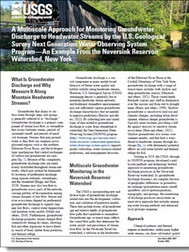
A Multiscale Approach for Monitoring Groundwater Discharge to Headwater Streams by the U.S. Geological Survey Next Generation Water Observing System Program—An Example From the Neversink Reservoir Watershed, New York

This product is not available for order, it can only be downloaded from here (click on image) or within the Publications Warehouse at https://pubs.er.usgs.gov/publication/fs20223077

First posted October 25, 2022

For additional information, contact:

Program Manager, Next Generation Water Observing System

https://www.usgs.gov/mission-areas/water-resources/science/ next-generation-water-observing-system-ngwos

Water Resources Mission Area

U.S. Geological Survey

12201 Sunrise Valley Drive

Reston, VA 20192

Abstract

Groundwater-stream connectivity across mountain watersheds is critical for supporting streamflow during dry times and keeping streams cool during warm times, yet U.S. Geological Survey (USGS) stream measurements are often sparse in headwaters. Starting in 2019, the USGS Next Generation Water Observing System Program developed a multiscale methods and technology testbed approach to monitoring groundwater discharge to streams in the Neversink Reservoir watershed in the Catskill Mountains of New York. Groundwater discharge dynamics are complex across space and time because of geographic variability, topography, and preferential groundwater flow patterns, and the monitoring of discharge processes necessitates an innovative approach that includes emerging water tracing methods and enhanced local geologic mapping. This fact sheet describes the multiscale monitoring approach applied in the Neversink Reservoir watershed and specifically how the varied data types are complimentary in understanding groundwater-stream connectivity, with elements transferable to other mountain watersheds.

Survey Date
2022
Print Date
2022
Height In Inches
11.000
Length In Inches
8.500
Languages
English
Related Items
THE USGS NATIONAL WATER DASHBOARD
<p> Water Priorities for the Nation—The USGS National Water Dashboard <p> </p> <font color=red><i> <p> This product is not available for order, it can only be downloaded from here (click on image) or within the Publications Warehouse at https://pubs.er.usgs.gov/publication/fs20223003 </p> </i> </font> <p> <p> First posted March 2, 2022 <p> For additional information, contact: Associate Director, Water Resources Mission Area https://www.usgs.gov/mission-areas/water-resources U.S. Geological Survey 12201 Sunrise Valley Drive Reston, VA 20192 <p> <p> Abstract <p> <p> The U.S. Geological Survey National Water Dashboard supplies critical information to decision makers, emergency managers, and the public during extreme hydrologic events (such as droughts and floods) and during normal hydrologic conditions. It informs decision making that can help protect lives and property before and during extreme hydrologic events. The National Water Dashboard draws upon the extensive site-specific hydrologic data housed in the U.S. Geological Survey National Water Information System database (https://doi.org/10.5066/F7P55KJN) and also links to the U.S. Geologic Survey WaterAlert system, which provides users with instant and customized updates about water conditions. Overall, the National Water Dashboard is part of the U.S. Geological Survey's effort to respond to 21st century science needs. <p>
Water Priorities for the Nation
<p> Prioridades de la nación referentes al agua— Panel Nacional del Agua del USGS <p> </p> <font color=red><i> <p> This product is not available for order, it can only be downloaded from here (click on image) or within the Publications Warehouse at https://pubs.er.usgs.gov/publication/fs20223003 </p> </i> </font> <p> <p> First posted March 2, 2022 <p> For additional information, contact: Associate Director, Water Resources Mission Area https://www.usgs.gov/mission-areas/water-resources U.S. Geological Survey 12201 Sunrise Valley Drive Reston, VA 20192 <p> <p> Abstract <p> <p> The U.S. Geological Survey National Water Dashboard supplies critical information to decision makers, emergency managers, and the public during extreme hydrologic events (such as droughts and floods) and during normal hydrologic conditions. It informs decision making that can help protect lives and property before and during extreme hydrologic events. The National Water Dashboard draws upon the extensive site-specific hydrologic data housed in the U.S. Geological Survey National Water Information System database (https://doi.org/10.5066/F7P55KJN) and also links to the U.S. Geologic Survey WaterAlert system, which provides users with instant and customized updates about water conditions. Overall, the National Water Dashboard is part of the U.S. Geological Survey's effort to respond to 21st century science needs. <p>
USGS INTEGRATED WATER PREDICTION SCIENCE
<p> Water Priorities for the Nation <p> U.S. Geological Survey Integrated Water Prediction Science Program <p> </p> <font color=red><i> <p> This product is not available for order, it can only be downloaded from here (click on image) or within the Publications Warehouse at https://pubs.er.usgs.gov/publication/fs20223028 </p> </i> </font> <p> <p> <p> First posted May 3, 2022 <p> <p> For additional information, contact: Water Resources Mission Area U.S. Geological Survey 12201 Sunrise Valley Drive Reston, VA 20192 <p> <p> Abstract <p> <p> The U.S. Geological Survey Integrated Water Prediction science program focuses on the development of advanced models for forecasting water use and other components of the water cycle along with water quality attributes such as temperature, water constituents, and ecological conditions. The program also is developing the cyberinfrastructure equired to implement national and local-scale models to be used by water resource managers over the decades ahead. <p>