Product

WHISPERS PROVIDING SITUATIONAL AWARENESS

$0.00
Available

Product Details

Product Number
534160
Series
FS-2022-3022
Scale
NO SCALE
Alternate ID
FS-2022-3022
Authors
BRYAN J RICHARDS
Version Date
06/01/2022
Countries
USA
Media
WEB ONLY
Format
WEB ONLY

Additional Details

Description

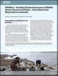
WHISPers—Providing Situational Awareness of Wildlife Disease Threats to the Nation—A Fact Sheet for the Biosurveillance Community

This product is not available for order, it can only be downloaded from here (click on image) or within the Publications Warehouse at https://pubs.er.usgs.gov/publication/fs20223022

First posted July 21, 2022

For additional information, contact: Director, National Wildlife Health Center National Land Imaging Program https://www.usgs.gov/centers/nwhc

U.S. Geological Survey

6006 Schroeder Road

Madison, WI 53711-6223

Abstract

Solutions for emerging infectious disease and bioterror threats can be improved by incorporating integrated biodefense strategies, including improved surveillance for animal and zoonotic diseases, strong national leadership, and effective management tools. Active biosurveillance for disease events is key to early detection, warning, and overall situational awareness and enables better communication, coordination, decision making, and data-driven responses. The national biosurveillance infrastructure has well-established channels for human and domestic animal health data through the Centers for Disease Control and Prevention and U.S. Department of Agriculture, and State, county, and local authorities. Wildlife disease information, however, has been more challenging to acquire and access, in part, due to the comparatively small infrastructure and resources dedicated to wildlife health and also because regulatory authority for wildlife and wildlife health is split among Federal, State, Tribal, and indigenous natural resource authorities. To address these issues, the Wildlife Health Information Sharing Partnership-event reporting system (WHISPers; https://whispers.usgs.gov) was developed by the U.S. Geological Survey National Wildlife Health Center to promote collaboration and sharing of wildlife health information and to provide situational awareness and timely information about wildlife disease threats. WHISPers is a free science gateway and data portal that provides interactive query, display, reporting, and export capabilities for wildlife health event summary information.

Survey Date
2022
Print Date
2022
Height In Inches
11.000
Length In Inches
8.500
Languages
English
Related Items
THE USGS NATIONAL WATER DASHBOARD
<p> Water Priorities for the Nation—The USGS National Water Dashboard <p> </p> <font color=red><i> <p> This product is not available for order, it can only be downloaded from here (click on image) or within the Publications Warehouse at https://pubs.er.usgs.gov/publication/fs20223003 </p> </i> </font> <p> <p> First posted March 2, 2022 <p> For additional information, contact: Associate Director, Water Resources Mission Area https://www.usgs.gov/mission-areas/water-resources U.S. Geological Survey 12201 Sunrise Valley Drive Reston, VA 20192 <p> <p> Abstract <p> <p> The U.S. Geological Survey National Water Dashboard supplies critical information to decision makers, emergency managers, and the public during extreme hydrologic events (such as droughts and floods) and during normal hydrologic conditions. It informs decision making that can help protect lives and property before and during extreme hydrologic events. The National Water Dashboard draws upon the extensive site-specific hydrologic data housed in the U.S. Geological Survey National Water Information System database (https://doi.org/10.5066/F7P55KJN) and also links to the U.S. Geologic Survey WaterAlert system, which provides users with instant and customized updates about water conditions. Overall, the National Water Dashboard is part of the U.S. Geological Survey's effort to respond to 21st century science needs. <p>
HYDROLOGIC CONDITIONS IN KANSAS, 2021
<p> Hydrologic Conditions in Kansas, Water Year 2021 <p> </p> <font color=red><i> <p> This product is not available for order, it can only be downloaded from here (click on image) or within the Publications Warehouse at https://pubs.er.usgs.gov/publication/fs20223071 </p> </i> </font> <p> <p> First posted August 19, 2022 <p> For additional information, contact: <p> Director, Kansas Water Science Center <p> https://www.usgs.gov/centers/kswsc <P> U.S. Geological Survey <p> 1217 Biltmore Drive <p> Lawrence, KS 66049 <p> <p> Abstract <p> <p> The U.S. Geological Survey maintains a network of hydrologic monitoring stations across Kansas in cooperation with Federal, State, Tribal, and local agencies. During water year 2021, this network included 230 real-time surface water data collection sites, referred to as “streamgages.” A water year is the 12-month period from October 1 through September 30 and is designated by the calendar year in which it ends. These real-time data are routinely collected and calibrated by U.S. Geological Survey personnel via regular measurements of streamflow and water levels. Analyses of these data provide an understanding of hydrologic conditions in the State critical to the management of water resources, industrial and agricultural uses, protection of life and property during flooding, operation of reservoirs, recreation, and other activities. <p>
USGS SCIENCE TO SUPPORT WILDLIFE DISEASE
<p> U.S. Geological Survey Science to Support Wildlife Disease Management <p> Fact Sheet 2023-3008 <p> Ecosystems Mission Area <p> By: M. Camille Hopkins and Suzanna C. Soileau </p> <font color=red><i> <p> This product is not available for order, it can only be downloaded from here (click on image) or within the Publications Warehouse at https://pubs.er.usgs.gov/publication/fs20233008 </p> </i> </font> <p> <p> First posted April 28, 2023 <p> For additional information, contact: <p> Associate Director, Ecosystems Mission Area <p> https://www.usgs.gov/mission-areas/ecosystems <p> U.S. Geological Survey <p> 12201 Sunrise Valley Drive <p> Mail Stop 300 <p> Reston, VA 20192 <p> Introduction <p> <p> The U.S. Geological Survey (USGS) serves a principal role in conducting wildlife disease outbreak investigations, surveillance, and ecological research to support management of diseases in free-ranging native wildlife. <p> Approximately 60 percent of emerging human infectious diseases such as COVID-19, are zoonotic, meaning they are transmitted between animals and humans and 70 percent of these diseases originate in wildlife (Jones and others, 2008). The effects of emerging wildlife diseases are global and profound, often resulting in economic and agricultural impacts, declines in wildlife populations, and ecological disturbances. <p>