


Product Details
- Product Number
- 242360
- Series
- SIM-2940
- Scale
- 1:200,000
- Alternate ID
- SIM2940
- ISBN
- 978-1-4113-2670-5
- Authors
- RALPH A HAUGERUD
- Version Date
- 01/01/2009
- Regions
- WA
- Countries
- USA
- Media
- Paper
- Format
- Folded
Additional Details
- Description
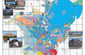
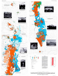
- The North Cascade Range, commonly referred to as the North Cascades, is the northern part of the Cascade Range that stretches from northern California into British Columbia, where it merges with the Coast Mountains of British Columbia at the Fraser River. The North Cascades are generally characterized by exposure of plutonic and metamorphic rocks in contrast to the volcanic terrain to the south. The rocks of the North Cascades are more resistant to erosion, display greater relief, and show evidence of more pronounced uplift and recent glaciation. Although the total length of the North Cascade Range, extending north from Snoqualmie Pass in Washington, is about 200 mi (320 km), this compilation map at 1:200,000 scale covers only that part (~150 mi) in the United States. The compilation map is derived mostly from eight 1:100,000-scale quadrangle maps that include all of the North Cascade Range in Washington and a bit of the mostly volcanic part of the Cascade Range to the south (fig. 1, sheet 2). Overall, the area represented by this compilation is about 12,740 mi2 (33,000 km2). The superb alpine scenery of the North Cascade Range and its proximity to major population centers has led to designation of much of the area for recreational use or wilderness preservation. A major part of the map area is in North Cascade National Park. Other restricted use areas are the Alpine Lakes, Boulder River, Clearwater, Glacier Peak, Henry M. Jackson, Lake Chelan-Sawtooth, Mount Baker, Noisy-Diobsud, Norse Peak, and Pasayten Wildernesses and the Mount Baker, Lake Chelan, and Ross L ake National Recreation Areas. The valleys traversed by Washington State Highway 20 east of Ross Lake are preserved as North Cascades Scenic Highway. The map area is traversed by three major highways: U.S. Interstate 90, crossing Snoqualmie Pass; Washington State Highway 2, crossing Stevens Pass; and Washington State Highway 20, crossing Washington Pass. Major secondary roads, as well as a network of U.S. Forest Service roads and a few private roads mainly used for logging, are restricted mostly to the flanks of the range. Although much of the mountainous core is inaccessible to automobiles, numerous trails serve the foot or horse traveler.
- Survey Date
- 2009
- Print Date
- 2009
- Boundary Type
- Quadrangle
- Two Sided
- No
- Pieces
- 3
- Languages
- English
Related Items
Geologic Map of Three Sisters Volcanic Cluster, Cascade Range, Oregon
Geologic map of upper Eocene to Holocene volcanic and related rocks in the Cascade Range, Washington
Map showing distribution, composition, and age of Late Cenozoic volcanoes and volcanic rocks of the Cascade Range and vicinity, northwestern United States