GEOLOGIC MAP THREE SISTERS VOLCANIC, OR

Product Details
- Product Number
- 378653
- Series
- SIM-3186
- Scale
- 1:24,000
- Alternate ID
- SIM3186
- ISBN
- 978-1-4113-3551-6
- Authors
- JUDY FIERSTEIN
- Version Date
- 01/01/2012
- Regions
- OR
- Countries
- USA
- Media
- Electronic (Physical)
- Format
- Folded
Additional Details
- Description
-
Summary
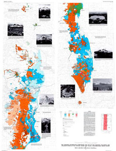
The cluster of glaciated stratovolcanoes called the Three Sisters—South Sister, Middle Sister, and North Sister—forms a spectacular 20-km-long reach along the crest of the Cascade Range in Oregon. The three eponymous stratocones, though contiguous and conventionally lumped sororally, could hardly display less family resemblance. North Sister (10,085 ft), a monotonously mafic edifice at least as old as 120 ka, is a glacially ravaged stratocone that consists of hundreds of thin rubbly lava flows and intercalated falls that dip radially and steeply; remnants of two thick lava flows cap its summit. Middle Sister (10,047 ft), an andesite-basalt-dacite cone built between 48 and 14 ka, is capped by a thick stack of radially dipping, dark-gray, thin mafic lava flows; asymmetrically glaciated, its nearly intact west flank contrasts sharply with its steep east face. Snow and ice-filled South Sister is a bimodal rhyolitic-intermediate edifice that was constructed between 50 ka and 2 ka; its crater (rim at 10,358 ft) was created between 30 and 22 ka, during the most recent of several explosive summit eruptions; the thin oxidized agglutinate that mantles its current crater rim protects a 150-m-thick pyroclastic sequence that helped fill a much larger crater. For each of the three, the eruptive volume is likely to have been in the range of 15 to 25 km³, but such estimates are fairly uncertain, owing to glacial erosion.
The map area consists exclusively of Quaternary volcanic rocks and derivative surficial deposits. Although most of the area has been modified by glaciation, the volcanoes are young enough that the landforms remain largely constructional. Furthermore, twelve of the 145 eruptive units on the map are postglacial, younger than the deglaciation that was underway by about 17 ka. The most recent eruptions were of rhyolite near South Sister, about 2,000 years ago, and of mafic magma near McKenzie Pass, about 1,500 years ago.
As observed by trailblazing volcanologist, Howel Williams, "For magnificence of glacial scenery, for wealth of recent lavas, and for graphic examples of dissected volcanoes, no part of this range surpasses the area embracing the Sisters and McKenzie Pass." Scientific and journalistic interest in the Three Sisters volcanic cluster was aroused a few years ago when ongoing uplift centered about 5 km west of South Sister was identified, first recognized by satellite imagery in 2001. Subsequent geodetic measurements and continuing satellite imagery analysis confirmed 3 to 4 cm/yr uplift during the interval from 1997 to 2004; the uplift has been modelled as inflation thought to be caused by an intracrustal intrusion, largely aseismic and plausibly involving mafic magma.
- Print Date
- 2012
- Two Sided
- No
- Pieces
- 3
- Languages
- English