
Product Details
- Product Number
- 212343
- Series
- FS-2009-3054
- Scale
- NO SCALE
- Alternate ID
- FS2009-3054
- Version Date
- 07/01/2009
- Countries
- USA
- Media
- Paper
- Format
- Folded
Additional Details
- Description
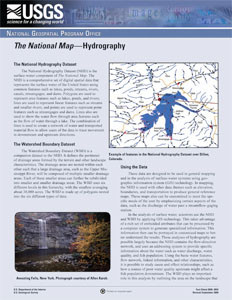
- 7/15/2009 Abstract The National Hydrography Dataset (NHD) is the surface-water component of The National Map. The NHD is a comprehensive set of digital spatial data that represents the surface water of the United States using common features such as lakes, ponds, streams, rivers, canals, streamgages, and dams. Polygons are used to represent area features such as lakes, ponds, and rivers; lines are used to represent linear features such as streams and smaller rivers; and points are used to represent point features such as streamgages and dams. Lines also are used to show the water flow through area features such as the flow of water through a lake. The combination of lines is used to create a network of water and transported material flow to allow users of the data to trace movement in downstream and upstream directions.
- Survey Date
- 2009
- Print Date
- 2009
- Height In Inches
- 11.000
- Length In Inches
- 8.500
- Two Sided
- Yes
- Pieces
- 1
- Languages
- English
Related Items