
Product Details

Product Number
11691
Series
PP-379
Scale
NO SCALE
Alternate ID
16-0379
ISBN
978-0-607-69794-0
Authors
LYFORD, WALTER HENRY
Version Date
01/01/1963
Regions
NV
Countries
USA
Media
Paper
Format
Bound

Additional Details

Description

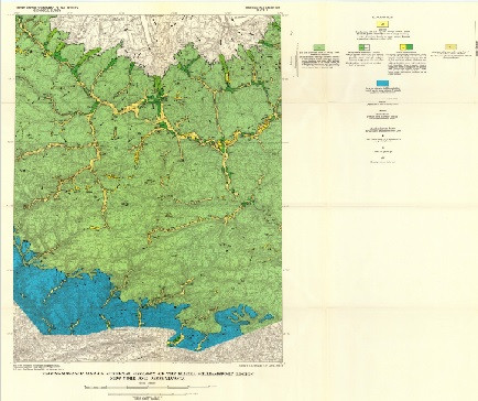
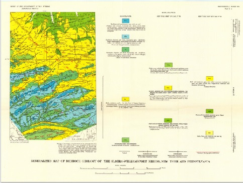
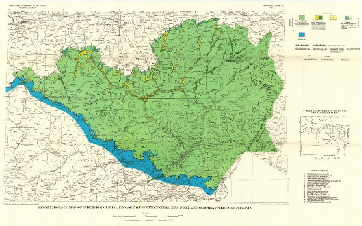
Surficial geology and soils of the Elmira-Williamsport region, New York and Pennsylvania, with a section on forest regions and great soil groups

Professional Paper 379

By: Charles Storrow Denny, Walter Henry Lyford, and J. C. Goodlett

https://doi.org/10.3133/pp379

Abstract

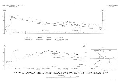
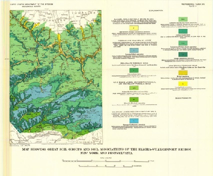
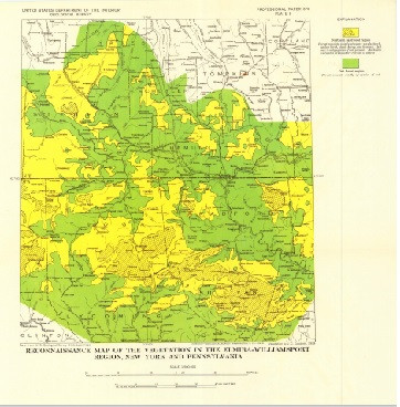
The Elmira-Williamsport region, lying south of the Finger Lakes in central New York and northern Pennsylvania, is part of the Appalachian Plateaus physiographic province. A small segment of the Valley and Ridge province is included near the south border. In 1953 and 1954, the authors, a geologist and a soil scientist, made a reconnaissance of about 5,000 square miles extending southward from the Finger Lakes, N.Y., to Williamsport, Pa., and eastward from Wellsboro, Pa., to Towanda, Pa. Glacial drift of Wisconsin age, covering the central and most of the northern parts of the region, belongs to the Olean substage of MacClintock and Apfel. This drift is thin and patchy, is composed of the relatively soft sandstones, siltstone, shales, and conglomerates of the plateaus, commonly has a low calcium carbonate content, and is deeply leached. Mantling its surface are extensive rubbly colluvial deposits. No conspicuous terminal moraine marks the relatively straight border of Olean drift. The Valley Heads moraine of Fairchild near the south ends of the Finger Lakes is composed of relatively thick drift containing a considerable amount of somewhat resistant sedimentary and crystalline rocks. Commonly this drift has a relatively high carbonate content and is leached to only shallow depths. The Valley Heads drift is younger than Olean, but its precise age is undetermined. The age of the Olean is perhaps between Sangamon and Farmdale, on the basis of, in part, a carbon-14 date from peat at Otto, N.Y. All differences in soil development on these two Wisconsin drifts are clearly related to the lithology of the parent material or the drainage, rather than to weathering differing in kind or in duration. The authors believe that the soils are relatively young, are in equilibrium with the present environment, and contain few, if any, features acquired during past weathering intervals. The effect of tree throw on soil profiles and the presence of soils on slopes clearly indicate that soils form rapidly. Sols Bruns Acides are the most extensive great soil group occurring throughout the region. Podzols and Gray-Brown Podzolic soils are also widespread, and on long, smooth slopes Low Humic-Gley soils are common. Organic soils are of small extent. South of the Wisconsin drift border, the surficial mantle consists chiefly of alluvial, colluvial, or residual deposits of Wisconsin or of Recent age, but there are many small isolated patches of older, strongly weathered materials of pre-Wisconsin age. Although such older materials are commonly overlain or mixed with less weathered mantle, the yellowish-red color, characteristic of the strongly weathered material, is generally not masked. Some of the older material is drift, presumed to be of Illionian age, that was probably strongly weathered to a considerable depth in Sangamon time and has been greatly eroded since the last interglacial period. No clear-cut exposure of Wisconsin drift resting on older drift or other strongly weathered mantle has been found. The old drift and the other strongly weathered materials apparently acquired their present red color in pre-Wisconsin time. Where exposed at the surface, such strongly weathered mantle is the parent material of modern Red-Yellow Podzolic soils. Sols Bruns Acides and Gray-Brown Podzolic soils, developed on slightly weathered parent materials, are found adjacent to these red soils. This suggests that these Red-Yellow Podzolic soils probably developed from strongly weathered parent materials. No buried soils were found nor were any soils recognized as relics from pre-Wisconsin time. Comparison of a map of the great soil groups with a map of the vegetation of the region, prepared by John C. Goodlett, does not reveal a close relation. Laboratory analyses of samples collected furnish data on textural, mineralogical, and chemical changes caused by weathering and soil formation. The results indicate that the amount of chemical weathering which the Wisconsin drift has undergone is slight. The Red-Yellow Podzolic soils on strongly weathered pre-Wisconsin drift have B2 horizons that have a finer texture than the A2 or C horizons. The parent materials of these soils seem to be strongly weathered because of the high chromas, reddish hues, friable condition of most rock fragments, relatively high kaolinite content, and presence of gibbsite in the clay fraction. Measurements at numerous localities show that the depth of leaching increases with decreasing carbonate content and is not a criterion of the age of the drift. Pebble counts of gravels also show that the depth of leaching of gravel is related to its limestone content. The location of the gravel deposits is probably due primarily to the presence of pebbles of resistant rock rather than to ice wastage involving abundant glacial melt water. The region is in the Susquehanna drainage basin except for its north fringe, which drains to Lake Ontario. Most of the region is a dissected plateau ranging in altitude from 700 to 2,500 feet and underlain by gently folded sedimentary rocks of Paleozoic age. Much of the region slopes moderately or steeply; the most extensive areas of gently sloping land are 011 the uplands. In the northern part are several straight and deep valleys the southern extension of the Finger Lakes basins separated by uplands with several low cuestas that face north. Similarly, some streams such as the Canisteo, Cohocton, and Chemung Rivers, and the part of the Susquehanna River that is in New York, trend at right angles to the Finger Lakes, flowing in valleys that parallel the regional strike of the bedrock. The Olean drift border is marked by a change from drift containing very few rounded or striated rock fragments to a mantle containing only angular rock fragments and traces of red, strongly weathered materials. A reconstruction of the surface of the ice sheet, at its maximum extent shows an inferred slope of its distal margin ranging from 100 to 500 feet per mile

Two Sided
No
Pieces
1
Languages
English
Related Items
MARINE MINERALS IN ALASKA A REVIEW OF
<p> Marine minerals in Alaska — A review of coastal and deep-ocean regions <p> <p> First posted July 14, 2022 <p> For additional information, contact: Pacific Coastal and Marine Science Center U.S. Geological Survey 2885 Mission St. Santa Cruz, CA 95060 <p> <p> Abstract <p> <p> Minerals occurring in marine environments span the globe and encompass a broad range of mineral categories, forming within varied geologic and oceanographic settings. They occur in coastal regions, either from the continuation or mechanical reworking of terrestrial mineralization, as well as in the deep ocean, from diagenetic, hydrogenetic, and hydrothermal processes. The oceans cover most of the Earth’s surface and as a result, any inventory of global resources is incomplete without the inclusion of marine minerals. This study by the U.S. Geological Survey reviews current knowledge regarding deep-ocean and coastal marine minerals within the marine areas surrounding Alaska, including the Alaska Outer Continental Shelf (OCS). For the purposes of this study, we have divided these areas in to eight regions: (1) Gulf of Alaska seamounts, (2) Chukchi Borderland, (3) Canada Basin, (4) Aleutian Arc, (5) Seward Peninsula, (6) Goodnews Bay, (7) Bristol Bay and Alaska Peninsula, and (8) southern and southeastern Alaska. The Alaska OCS encompasses several areas broadly conducive to marine mineral formation, including extensional basins resulting from an active subduction zone where massive sulfide deposits may form, deep abyssal plains with conditions that may lead to manganese nodule formation, seamounts that can provide substrate for the growth of ferromanganese crusts, and erosional settings and submerged continental crust where placer deposits are found. For deep-ocean hydrothermal minerals and manganese nodules, the Alaska OCS contains prospective regions, including the Canada Basin and the Aleutian Arc; however, no such minerals have yet been identified. We explore the probability that these minerals occur based on reviews of existing geologic and oceanographic data within the relevant sections. In regions far from shore data are limited. Deep-ocean ferromanganese crusts are known to occur in two regions: (1) the Gulf of Alaska seamounts and (2) the Chukchi Borderland in the Arctic Ocean. Limited sampling has occurred in both regions, and along the Chukchi Borderland the sampling was outside of the OCS and the U.S. Exclusive Economic Zone. Data relevant to coastal minerals is more extensive, and in some places fairly systematic sampling was conducted. Several nearshore placer deposits have been exploited for decades; however, the potential for nearshore extension of terrestrial ore deposits is less well considered. This contribution considers the state of knowledge regarding marine mineral occurrences within the Alaska regions and identifies the data gaps in order to help inform future marine mineral related research efforts around Alaska. <p>
STREAMS OF FAIRFAX COUNTY, VA
Evaluating Drivers of Hydrology, Water Quality, and Benthic Macroinvertebrates in Streams of Fairfax County, Virginia, 2007–18 <p> <p> Scientific Investigations Report 2023-5027 <p> <p> Prepared in cooperation with Fairfax County, Virginia <p> By: James S. Webber, Jeffrey G. Chanat, Aaron J. Porter, and John D. Jastram <p> <p> https://doi.org/10.3133/sir20235027 <p> <p> First posted May 18, 2023 <p> For additional information, contact: <p> Director, Virginia and West Virginia Water Science Center <p> https://www.usgs.gov/centers/virginia-and-west-virginia-water-science-ce nter <p> U.S. Geological Survey <p> 1730 East Parham Road <p> Richmond, VA 23228 <p> <p> Abstract <p> <p> In 2007, the U.S. Geological Survey partnered with Fairfax County, Virginia, to establish a long-term water-resources monitoring program to evaluate the hydrology, water quality, and ecology of Fairfax County streams and the watershed-scale effects of management practices. Fairfax County uses a variety of management practices, policies, and programs to protect and restore its water resources, but the effects of such strategies are not well understood. This report used streamflow, water-quality, and ecological monitoring data collected from 20 Fairfax County watersheds from 2007 through 2018 to assess the effects of management practices, landscape factors, and climatic conditions on observed nutrient, sediment, salinity, and benthic-macroinvertebrate community responses. <p> <p> Urbanization, climatic variability, and an increase in management practices occurred within Fairfax County during the study period. Impervious cover, housing units, wastewater infrastructure, and (or) stormwater infrastructure increased in most study watersheds. Climatic conditions varied among study years; countywide estimates of average-annual air temperature differed by about 3 degrees Celsius, and total precipitation ranged from about 34 to 63 inches per year. The effects of the management practices, implemented to reduce nitrogen, phosphorus, and (or) sediment loads, are considered in this study. These management practices primarily consist of stormwater retrofits and stream restorations; however, stream restorations account for most of the financial investment and expected load reductions. Management practices were implemented in half of the study watersheds, and most practices were installed and reductions credited late in the study period. <p> <p> Changes in hydrologic response during storm events were evaluated over the study period because many management practices that were implemented were designed to achieve nutrient and sediment reductions by slowing or intercepting runoff. The average number and length of storm events was mostly unchanged throughout the monitoring network. Four watersheds with 10 years of streamflow data showed a mixture of trends in stormflow peak, volume, and rate-of-change. Event-mean nutrient and sediment concentrations from these watersheds were evaluated during storm events and generally showed increases in total phosphorus (TP) and suspended sediment and reductions or no changes in total nitrogen (TN). <p> <p> Landscape inputs of nitrogen and phosphorus and the percentage of inputs delivered to streams were estimated for the study watersheds. Estimated phosphorus from fertilizer and nitrogen from atmospheric deposition represented large nutrient inputs in most watersheds; amounts of other nonpoint sources varied based on land use. Estimated nitrogen inputs declined throughout Fairfax County and in most study watersheds from 2008 through 2018; in comparison, phosphorus input changes were relatively small. Most nonpoint-nutrient inputs were retained on the landscape and did not reach streams, with slightly more nitrogen retention than phosphorus, on average. Retention rates were lower for years with more precipitation and streamflow. After adjusting for streamflow, TN and TP loads were generally higher for years with more nutrient inputs. Calculated as a function of flow-adjusted loads, TP retention declined at most stations from 2009 through 2018, in comparison, TN retention was relatively unchanged. Landscape and climatic conditions affected spatial differences and changes in Fairfax County stream conditions from 2009 through 2018. TN concentrations were higher and increases over time were larger in watersheds with elevated septic-system density. TP concentrations were higher in watersheds with more turfgrass; concentrations were lower, but had larger increases over time, in watersheds with deeper soils. Suspended-sediment concentrations were higher in watersheds with greater stream densities. Specific conductance was higher in watersheds with more developed land use and shallower soils. Benthic-macroinvertebrate index of biotic integrity (IBI) scores were lower in watersheds with high road density and had larger increases over time in bigger, more developed watersheds. Annual variability in TN and TP concentrations and benthic-macroinvertebrate IBI scores was affected by precipitation; annual variability in suspended sediment concentrations and specific conductance was affected by air temperature. <p> <p> After accounting for influences from landscape and climatic conditions, expected management-practice effects were not consistently observed in monitored stream responses. These effects were assessed by comparing expected management-practice load reductions with the timing, direction, and magnitude of changes in storm-event hydrology, nutrient and sediment loads, median-annual water-quality conditions, and benthic-macroinvertebrate IBI scores. An important consideration for future investigations of management-practice effects is how to control for water-quality and ecological variability caused by geologic properties, the urban environment, precipitation, and (or) air temperature. The interpretation of management-practice effects in this report was likely influenced by a combination of factors, including (1) the amount, timing, and location of management-practice implementation; (2) unmeasured landscape and climatic factors; (3) uncertain management-practice expectations; (4) hydrologic variability; and (5) analytical assumptions. Through continued data-collection efforts, particularly after management practices have been completed, many of these factors may become less influential in the future. <p>
HYDROGEOLOGY, KARST, GROUNDWATER, WV
Hydrogeology, Karst, and Groundwater Availability of Monroe County, West Virginia <p> <p> Scientific Investigations Report 2023-5121 <p> Prepared in cooperation with the West Virginia Department of Environmental Protection, the West Virginia Department of Health & Human Resources, and the Monroe County Commission <p> <p> By: Mark D. Kozar, Daniel H. Doctor, William K. Jones, Nathan Chien, Cheyenne E. Cox, Randall C. Orndorff, David J. Weary, Mitchell R. Weaver, Mitchell A. McAdoo, and Mercer Parker <p> <p> https://doi.org/10.3133/sir20235121 <p> <p> First posted December 14, 2023 <p> For additional information, contact: <p> Director, Virginia and West Virginia Water Science Center <p> https://www.usgs.gov/centers/va-wv-water <p> <p> U.S. Geological Survey <p> 1730 East Parham Road <p> Richmond, Virginia 23228 <p> <p> Abstract <p> <p> Monroe County is in southeastern West Virginia, encompassing an area of 474 square miles. The area consists of karst and siliciclastic aquifers of Ordovician, Silurian, Devonian, and Mississippian age and is in parts of two physiographic provinces: the Valley and Ridge Province to the east of Peters Mountain, and the Appalachian Plateau Province to the west of Peters Mountain. This study was developed in response to inquiries from the Monroe County Commission requesting assessment of the water resources of the county to better understand the quantity of the county’s groundwater resources, for both current [2023] and future demand, and to provide information to support protection and management of the county’s valuable groundwater resources. <p> <p> Various products were developed for this study that provide knowledge with respect to water availability and contamination susceptibility of the karst aquifers within the county. U.S. Geological Survey (USGS) geologists conducted extensive geologic mapping in support of the project, producing (1) a countywide bedrock geologic map, (2) a countywide hydrogeologic map, and (3) a light detection and ranging (lidar)-derived countywide digital elevation model and associated sinkhole map. A significant part of this work was to map in detail the Greenbrier Group at the formation level, which prior to this study had only partially been completed. The report also includes (4) a description of the lithologic units identified as part of the geologic mapping process. <p> <p> U.S. Geological Survey hydrologists completed several additional products for the hydrology part of the effort, including development of (1) a countywide potentiometric surface (water-table) map, (2) a countywide base-flow stream assessment, (3) countywide water-budget estimates, (4) well log surveys for 15 wells to better understand subsurface controls on groundwater flow within the study area, (5) two groundwater tracer tests to better refine the groundwater divide from the northern and southern parts of the karst aquifer in Monroe County; and finally, based on all available data collected for the study including the potentiometric surface map, geologic map, current [2023] and legacy fluorometric groundwater tracer tests, and base-flow stream assessments, (6) groundwater-basin delineations were reassessed for principal groundwater basins within the Greenbrier aquifer. <p> <p> In Monroe County, four principal hydrogeologic settings produce large yields of water for residential, agricultural, and other uses. The most relied upon water-bearing zone with respect to current [2023] public water supply is from springs along Peters Mountain. These springs are derived from intervals of fractured sandstone and resultant alluvial deposits. Groundwater flows downslope through these permeable alluvial deposits and discharges at the contact with less permeable strata, such as the Reedsville Shale. The second most relied upon water-bearing zone in Monroe County is within the karstic Greenbrier Group aquifer, in which the basal Hillsdale Limestone overlies the less permeable Maccrady Shale. This geologic contact between the Hillsdale Limestone and Maccrady Shale is not only targeted as a source of water for agricultural supply but also is targeted as a source of water for residential supply. The third most relied upon water-bearing zone is composed of shallow perched aquifers within the Greenbrier Group. The discontinuous nature of these perched aquifers makes mapping their extent impossible, but they are related to permeable geologic strata, such as karstified limestones with solutionally enhanced permeability that overlies less permeable shale or chert bedrock. During geologic mapping of the county, several of these perched aquifers were documented in the Pickaway, Union, and Alderson Limestones. A fourth zone consists of springs from Ordovician carbonates at the base of Peters Mountain, which are influenced by sinking streams as well as upwelling along faults. In terms of water quantity, the most sustainable springs are those having deeper-sourced flows. <p> <p> Public supplies are a principal source of water used for residential and commercial supply in the region, accounting for 0.49 million gallons per day (Mgal/d) of fresh-water withdrawals (0.14 Mgal/d of groundwater and 0.35 Mgal/d of surface water) for residential and commercial use and serving 6,645 individuals (49.2 percent of the population). An estimated 6,861 people, (50.8 percent of the population) primarily rely on private wells or other unregulated sources, such as springs, and withdraw 0.55 Mgal/d of groundwater for their residential use. Public water supply in the region is primarily (71.4 percent) derived from springs and augmented by stream withdrawals (backup sources mainly during low-flow periods), with the remaining portion (28.6 percent) derived from groundwater withdrawals from wells. For rural residents, however, 100 percent of their withdrawals are derived from groundwater (wells or springs). <p>