
- Added WELL SPRING, TN to cart. View cart.
- Added PURCELL, CO HISTORICAL MAP GEOPDF 7.5X7. to cart. View cart.
- Added ANTLER PEAK, NV to cart. View cart.
- Added HOOD RIVER, OR-WA HISTORICAL MAP GEOPDF to cart. View cart.
- Added COWCREEK, KY to cart. View cart.
- Added KNOXVILLE, CA to cart. View cart.
- Added NORTH PALISADE, CA HISTORICAL MAP GEOPDF to cart. View cart.
- Added HEATHSVILLE, VA to cart. View cart.
- Added MARS HILL, NC to cart. View cart.
- Added CHESTERFIELD, VA to cart. View cart.
- Added STAHL PEAK OE N, MT to cart. View cart.
- Added CATHEDRAL BUTTE, UT to cart. View cart.
- Added MCCLURE RESERVOIR, NM to cart. View cart.
- Added GALLATIN, WY-MT HISTORICAL MAP GEOPDF 30 to cart. View cart.
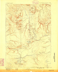

Product Details
- Product Number
- 930062
- Scale
- 1:125,000
- Version Date
- 01/01/1885
- Media
- Paper
- Format
- Flat
- Digital Reproduction
- Yes
Additional Details
- Description
- GALLATIN, WY-MT HISTORICAL MAP GEOPDF 30X30 GRID 125000-SCALE 1885
- Survey Date
- 1885
- Print Date
- 1886
- Boundary Type
- Quadrangle
- Pieces
- 1
Related Items
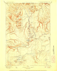
GALLATIN, WY-MT HISTORICAL MAP GEOPDF 30X30 GRID 125000-SCALE 1908
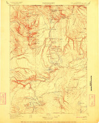
GALLATIN, WY-MT HISTORICAL MAP GEOPDF 30X30 GRID 125000-SCALE 1911
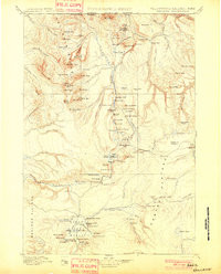
GALLATIN, WY-MT HISTORICAL MAP GEOPDF 30X30 GRID 125000-SCALE 1901