

Product Details
- Product Number
- 534042
- Series
- FS-2021-3041
- Scale
- NO SCALE
- Alternate ID
- FS-2021-3041
- Authors
- L A SPRAGUE
- Version Date
- 07/01/2021
- Countries
- USA
- Media
- WEB ONLY
- Format
- WEB ONLY
Additional Details
- Description
-
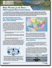
Water Priorities for the Nation - USGS Integrated Water Science Basins
This product is not available for order, it can only be downloaded from here (click on image) or within the Publications Warehouse at https://pubs.er.usgs.gov/publication/fs20213041
First posted July 27, 2021
For additional information, contact:
Water Resources Mission Area U.S. Geological Survey 12201 Sunrise Valley Drive Reston, VA 20192
Contact Pubs Warehouse
Abstract
The United States faces growing challenges to its water supply, infrastructure, and aquatic ecosystems because of population growth, climate change, floods, and droughts. To help address these challenges, the U.S. Geological Survey Water Resources Mission Area is integrating recent advances in monitoring, research, and modeling to improve assessments of water availability throughout the United States. A key part of this effort is the intensive study of 10 Integrated Water Science (IWS) basins across the Nation between 2019 and 2028.
The goal is to study 10 IWS basins that are representative of large geographic regions across the United States and that encompass a variety of potential threats to the amount and quality of water across the Nation. Lessons learned from these smaller IWS basins (10,000–20,000 square miles in size) about the interactions among climate, human effects, surface water, groundwater, water quality, and water supply and demand will be used to help quantify and forecast water availability in the larger regions and ultimately the Nation.
- Survey Date
- 2021
- Print Date
- 2021
- Height In Inches
- 11.000
- Length In Inches
- 8.500
- Languages
- English

