Product

EDMAP TRAINING THE NEXT GENERATION OF

$0.00
Available

Product Details

Product Number
534267
Series
FS-2023-3002
Scale
NO SCALE
Alternate ID
FS-2023-3002
Authors
CHRISTOPHER S SWEZEY
Version Date
01/01/2023
Countries
USA
Media
WEB ONLY
Format
WEB ONLY

Additional Details

Description
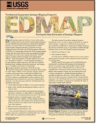
The EDMAP Program: Training the Next Generation of Geologic Mappers

Fact Sheet 2023-3002

National Cooperative Geologic Mapping Program

By: Jenna L. Shelton, Christopher S. Swezey, and Michael Marketti

This product is not available for order, it can only be downloaded from here (click on image) or within the Publications Warehouse at https://pubs.er.usgs.gov/publication/fs20233002

For additional information, contact:

National Cooperative Geologic Mapping Program

https://www.usgs.gov/programs/national-cooperative-geologic-mapping-prog ram

U.S. Geological Survey

12201 Sunrise Valley Drive, MS 908

Reston, VA 20192

Introduction

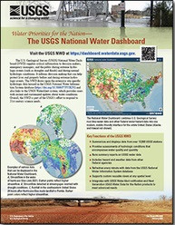
Detailed geologic maps are the basis of most earth science investigations and can be used for natural hazard mitigation, resource identification and exploration, infrastructure planning, and more. As a part of the U.S. Geological Survey (USGS) congressionally mandated National Cooperative Geologic Mapping Program (NCGMP), the EDMAP program (referred to as EDMAP) is a partnership between the USGS and participating colleges and universities that provides mentorship and training opportunities for earth science students nationwide. EDMAP supports graduate students and upper-level undergraduate students—under the guidance of a faculty member who serves as a “principal investigator”—for the training of students to become geologic mappers. Between 1996 and 2021, EDMAP funded geologic mapping educational experiences and training for 1,373 students at more than 170 universities.

Survey Date
2023
Print Date
2023
Height In Inches
11.000
Length In Inches
8.500
Languages
English
Related Items
THE USGS NATIONAL WATER DASHBOARD
<p> Water Priorities for the Nation—The USGS National Water Dashboard <p> </p> <font color=red><i> <p> This product is not available for order, it can only be downloaded from here (click on image) or within the Publications Warehouse at https://pubs.er.usgs.gov/publication/fs20223003 </p> </i> </font> <p> <p> First posted March 2, 2022 <p> For additional information, contact: Associate Director, Water Resources Mission Area https://www.usgs.gov/mission-areas/water-resources U.S. Geological Survey 12201 Sunrise Valley Drive Reston, VA 20192 <p> <p> Abstract <p> <p> The U.S. Geological Survey National Water Dashboard supplies critical information to decision makers, emergency managers, and the public during extreme hydrologic events (such as droughts and floods) and during normal hydrologic conditions. It informs decision making that can help protect lives and property before and during extreme hydrologic events. The National Water Dashboard draws upon the extensive site-specific hydrologic data housed in the U.S. Geological Survey National Water Information System database (https://doi.org/10.5066/F7P55KJN) and also links to the U.S. Geologic Survey WaterAlert system, which provides users with instant and customized updates about water conditions. Overall, the National Water Dashboard is part of the U.S. Geological Survey's effort to respond to 21st century science needs. <p>
EARTHQUAKE EARLY WARNING SYSTEMS USGS
Comparison of Earthquake Early Warning Systems and the National Volcano Early Warning System at the U.S. Geological Survey <p> Fact Sheet 2023-3033 <p> Volcano Hazards Program <p> By: Aleeza Wilkins, Charlie Mandeville, John Power, and Doug Given <p> https://doi.org/10.3133/fs20233033 <p> <p> </p> <font color=red> <i> This product is not available for order, it can only be downloaded from here (click on image) or within the Publications Warehouse at https://pubs.usgs.gov/publication/fs20233033 </p> </i> </font> <p> U.S. Geological Survey <p> 12201 Sunrise Valley Dr., Mail Stop 905 <p> Reston, VA 20192 <p> <p>
USGS INTEGRATED WATER PREDICTION SCIENCE
<p> Water Priorities for the Nation <p> U.S. Geological Survey Integrated Water Prediction Science Program <p> </p> <font color=red><i> <p> This product is not available for order, it can only be downloaded from here (click on image) or within the Publications Warehouse at https://pubs.er.usgs.gov/publication/fs20223028 </p> </i> </font> <p> <p> <p> First posted May 3, 2022 <p> <p> For additional information, contact: Water Resources Mission Area U.S. Geological Survey 12201 Sunrise Valley Drive Reston, VA 20192 <p> <p> Abstract <p> <p> The U.S. Geological Survey Integrated Water Prediction science program focuses on the development of advanced models for forecasting water use and other components of the water cycle along with water quality attributes such as temperature, water constituents, and ecological conditions. The program also is developing the cyberinfrastructure equired to implement national and local-scale models to be used by water resource managers over the decades ahead. <p>