Product

GROUNDWATER RESOURCES HARNEY BASIN SE OR

$0.00
Available

Product Details

Product Number
534166
Series
FS-2022-3052
Scale
NO SCALE
Alternate ID
FS-2022-3052
Authors
C AMANDA GARCIA
Version Date
09/01/2022
Regions
OR
Countries
USA
Media
WEB ONLY
Format
WEB ONLY

Additional Details

Description

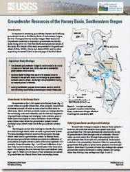
Groundwater Resources of the Harney Basin, Southeastern Oregon

This product is not available for order, it can only be downloaded from here (click on image) or within the Publications Warehouse at https://pubs.er.usgs.gov/publication/fs20223052

First posted August 3, 2022

For additional information, contact:

Director, Oregon Water Science Center

https://www.usgs.gov/centers/or-water

U.S. Geological Survey

911 NE 11th Avenue

Portland, Oregon 97232

Abstract

In response to increasing groundwater demand and declining groundwater levels in the Harney Basin of southeastern Oregon, the U.S. Geological Survey and the Oregon Water Resources Department conducted a cooperative groundwater-availability study during 2016–22. This Fact Sheet summarizes the results of this study. Full details of the study are provided in Gingerich and others (2022a, 2022b), Garcia and others (2022), and the other supporting documents listed on the last page of this Fact Sheet.

Survey Date
2022
Print Date
2022
Height In Inches
11.000
Length In Inches
8.500
Languages
English
Related Items
THE USGS NATIONAL WATER DASHBOARD
<p> Water Priorities for the Nation—The USGS National Water Dashboard <p> </p> <font color=red><i> <p> This product is not available for order, it can only be downloaded from here (click on image) or within the Publications Warehouse at https://pubs.er.usgs.gov/publication/fs20223003 </p> </i> </font> <p> <p> First posted March 2, 2022 <p> For additional information, contact: Associate Director, Water Resources Mission Area https://www.usgs.gov/mission-areas/water-resources U.S. Geological Survey 12201 Sunrise Valley Drive Reston, VA 20192 <p> <p> Abstract <p> <p> The U.S. Geological Survey National Water Dashboard supplies critical information to decision makers, emergency managers, and the public during extreme hydrologic events (such as droughts and floods) and during normal hydrologic conditions. It informs decision making that can help protect lives and property before and during extreme hydrologic events. The National Water Dashboard draws upon the extensive site-specific hydrologic data housed in the U.S. Geological Survey National Water Information System database (https://doi.org/10.5066/F7P55KJN) and also links to the U.S. Geologic Survey WaterAlert system, which provides users with instant and customized updates about water conditions. Overall, the National Water Dashboard is part of the U.S. Geological Survey's effort to respond to 21st century science needs. <p>
USGS INTEGRATED WATER PREDICTION SCIENCE
<p> Water Priorities for the Nation <p> U.S. Geological Survey Integrated Water Prediction Science Program <p> </p> <font color=red><i> <p> This product is not available for order, it can only be downloaded from here (click on image) or within the Publications Warehouse at https://pubs.er.usgs.gov/publication/fs20223028 </p> </i> </font> <p> <p> <p> First posted May 3, 2022 <p> <p> For additional information, contact: Water Resources Mission Area U.S. Geological Survey 12201 Sunrise Valley Drive Reston, VA 20192 <p> <p> Abstract <p> <p> The U.S. Geological Survey Integrated Water Prediction science program focuses on the development of advanced models for forecasting water use and other components of the water cycle along with water quality attributes such as temperature, water constituents, and ecological conditions. The program also is developing the cyberinfrastructure equired to implement national and local-scale models to be used by water resource managers over the decades ahead. <p>
Water Priorities for the Nation
<p> Prioridades de la nación referentes al agua— Panel Nacional del Agua del USGS <p> </p> <font color=red><i> <p> This product is not available for order, it can only be downloaded from here (click on image) or within the Publications Warehouse at https://pubs.er.usgs.gov/publication/fs20223003 </p> </i> </font> <p> <p> First posted March 2, 2022 <p> For additional information, contact: Associate Director, Water Resources Mission Area https://www.usgs.gov/mission-areas/water-resources U.S. Geological Survey 12201 Sunrise Valley Drive Reston, VA 20192 <p> <p> Abstract <p> <p> The U.S. Geological Survey National Water Dashboard supplies critical information to decision makers, emergency managers, and the public during extreme hydrologic events (such as droughts and floods) and during normal hydrologic conditions. It informs decision making that can help protect lives and property before and during extreme hydrologic events. The National Water Dashboard draws upon the extensive site-specific hydrologic data housed in the U.S. Geological Survey National Water Information System database (https://doi.org/10.5066/F7P55KJN) and also links to the U.S. Geologic Survey WaterAlert system, which provides users with instant and customized updates about water conditions. Overall, the National Water Dashboard is part of the U.S. Geological Survey's effort to respond to 21st century science needs. <p>