SEISMIC HAZARD MAPS FOR COUNTERMINOUS US

Product Details
- Product Number
- 342727
- Series
- SIM-3195
- Scale
- 1:7,000,000
- Alternate ID
- SIM3195
- Authors
- YUEHUA ZENG
- Version Date
- 01/01/2011
- Countries
- USA
- Media
- Paper
- Format
- Flat
Additional Details
- Description
-
Abstract
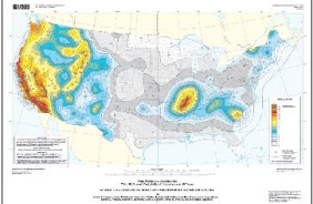
Probabilistic seismic-hazard maps were prepared for the conterminous United States portraying peak horizontal acceleration and horizontal spectral response acceleration for 0.2- and 1.0-second periods with probabilities of exceedance of 10 percent in 50 years and 2 percent in 50 years. All of the maps were prepared by combining the hazard derived from spatially smoothed historic seismicity with the hazard from fault-specific sources. The acceleration values contoured are the random horizontal component. The reference site condition is firm rock, defined as having an average shear-wave velocity of 760 m/s in the top 30 meters corresponding to the boundary between NEHRP (National Earthquake Hazards Reduction program) site classes B and C.
This data set represents the results of calculations of hazard curves for a grid of points with a spacing of 0.05 degrees in latitude and longitude. The grid of points were contoured to produce the final representation of the seismic-hazard.
These maps are intended to summarize the available quantitative information about seismic ground motion hazard for the conterminous United States from geologic and geophysical source.
- Height In Inches
- 24.000
- Length In Inches
- 31.000
- Two Sided
- No
- Pieces
- 6
- Languages
- English