Product Details
- Product Number
- 315781
- Series
- SIM-3180
- Scale
- NO SCALE
- Alternate ID
- SIM3180
- ISBN
- 978-1-4113-3298-0
- Authors
- LAURA L HALLBERG
- Version Date
- 01/01/2011
- Regions
- WY
- Countries
- USA
- Media
- Paper
- Format
- Folded
Additional Details
- Description
-
Abstract
The High Plains aquifer system, commonly called the High Plains aquifer in many publications, is a nationally important water resource that underlies a 111-million-acre area (173,000 square miles) in parts of eight States including Wyoming. Through irrigation of crops with groundwater from the High Plains aquifer system, the area that overlies the aquifer system has become one of the major agricultural regions in the world. In addition, the aquifer system also serves as the primary source of drinking water for most residents of the region. The High Plains aquifer system is one of the largest aquifers or aquifer systems in the world.
The High Plains aquifer system underlies an area of 8,190 square miles in southeastern Wyoming. Including Laramie County, the High Plains aquifer system is present in parts of five counties in southeastern Wyoming. The High Plains aquifer system underlies 8 percent of Wyoming, and 5 percent of the aquifer system is located within the State. Based on withdrawals for irrigation, public supply, and industrial use in 2000, the High Plains aquifer system is the most utilized source of groundwater in Wyoming.
With the exception of the Laramie Mountains in western Laramie County, the High Plains aquifer system is present throughout Laramie County. In Laramie County, the High Plains aquifer system is the predominant groundwater resource for agricultural (irrigation), municipal, industrial, and domestic uses. Withdrawal of groundwater for irrigation (primarily in the eastern part of the county) is the largest use of water from the High Plains aquifer system in Laramie County and southeastern Wyoming.
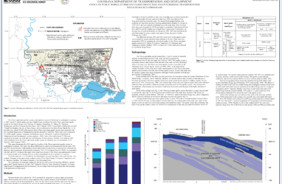
Continued interest in groundwater levels in the High Plains aquifer system in Laramie County prompted a study by the U.S. Geological Survey in cooperation with the Wyoming State Engineer's Office to update the potentiometric-surface map of the aquifer system in Laramie County. Groundwater levels were measured in wells completed in the High Plains aquifer system from March to June 2009. The groundwater levels were used to construct a map of the potentiometric surface of the High Plains aquifer system. In addition, depth to water and estimated saturated-thickness maps of the aquifer system were constructed using the potentiometric-surface map.
- Survey Date
- 2011
- Two Sided
- No
- Pieces
- 1
- Languages
- English