

Product Details
- Product Number
- 28901
- Scale
- 1:100,000
- Alternate ID
- GI2742-1T
- ISBN
- 978-0-607-96826-2
- Version Date
- 01/01/2001
- Regions
- FL
- Countries
- USA
- Media
- Paper
- Format
- Flat
Additional Details
- Description
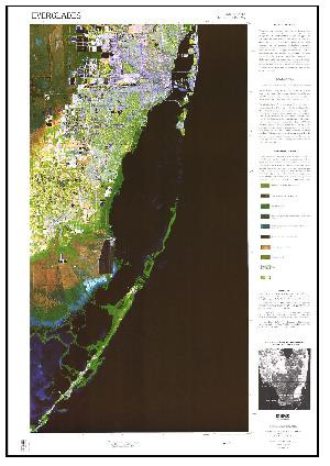
- (SOLD IN 2 PIECES-EAST <(>&<)> WEST) East Half*, Southern Everglades. * Florida; West ordering number is 28902 Everglades Satellite Image Map. This colorful satellite image map is the product of the U.S. Geological Survey's Land Characteristics from Remote Sensing Project with support from the Everglades National Park. The objective of this project is to develop and apply innovative remote sensing and geographic information system techniques to map the distribution of vegetation, vegetation characteristics, and related hydrologic variables.
- Survey Date
- 2001
- Print Date
- 2001
- Height In Inches
- 44.750
- Length In Inches
- 30.250
- Boundary Type
- Quadrangle
- Two Sided
- No
- Pieces
- 1
- Languages
- English
Related Items


