


Product Details
- Product Number
- 28732
- Series
- I-2562
- Scale
- 1:12,000
- Alternate ID
- GI2562D
- Authors
- BARTON, CHRISTOPHER CRAMER
- Version Date
- 01/01/1997
- Regions
- NH
- Countries
- USA
- Media
- Paper
- Format
- Folded
Additional Details
- Description
- Bedrock geologic map of Hubbard Brook Experimental Forest and maps of fractures and geology in roadcuts along Interstate 93, Grafton County, New Hampshire
- Survey Date
- 1997
- Print Date
- 1997
- Boundary Type
- Quadrangle
- Two Sided
- No
- Pieces
- 1
- Languages
- English
Related Items
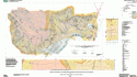
Geologic Map-Bedrock Geologic Map of the Hubbard Brook Experimental Forest, Grafton County, New Hampshire sht 1, refer to 116742 sht 2
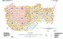
Fracture Map-Bedrock Geologic Map of the Hubbard Brook Experimental Forest, Grafton County, New Hampshire Sht 2, refer to 116740 sht 1