


Product Details
- Product Number
- 250662
- Series
- SIM-3147
- Scale
- NO SCALE
- Alternate ID
- SIM3147
- Authors
- SHANA L MASHBURN
- Version Date
- 01/01/2011
- Media
- Paper
- Format
- Folded
Additional Details
- Description
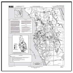
- A study of the hydrogeology of the Central Oklahoma aquifer was started in 2008 to provide the Oklahoma Water Resources Board (OWRB) hydrogeologic data and a groundwater flow model that can be used as a tool to help manage the aquifer. The 1973 Oklahoma water law requires the OWRB to do hydrologic investigations of Oklahoma's aquifers (termed "groundwater basins") and to determine amounts of water that may be withdrawn by permitted water users. "Maximum annual yield" is a term used by OWRB to describe the total amount of water that can be withdrawn from a specific aquifer in any year while allowing a minimum 20-year life of the basin (Oklahoma Water Resources Board, 2010). Currently (2010), the maximum annual yield has not been determined for the Central Oklahoma aquifer. Until the maximum annual yield determination is made, water users are issued a temporary permit by the OWRB for 2 acre-feet/acre per year. The objective of the study, in cooperation with the Oklahoma Water Resources Board, was to study the hydrogeology of the Central Oklahoma aquifer to provide information that will enable the OWRB to determine the maximum annual yield of the aquifer based on different proposed management plans. Groundwater flow models are typically used by the OWRB as a tool to help determine the maximum annual yield. This report presents the potentiometric surface of the Central Oklahoma aquifer based on water-level data collected in 2009 as part of the current (2010) hydrologic study. The U.S. Geological Survey (USGS) Hydrologic Investigations Atlas HA#724 by Christenson and others (1992) presents the 1986#87 potentiometric-surface map. This 1986#87 potentiometric-surface map was made as part of the USGS National Water-Quality Assessment pilot project for the Central Oklahoma aquifer that examined the geochemical and hydrogeological processes operating in the aquifer. An attempt was made to obtain water-level measurements for the 2009 potentiometric-surface map from the wells used for the 1986#87 potentiometric-surface map. Well symbols with circles on the 2009 potentiometric-surface map (fig. 1) indicate wells that were used for the 1986#87 potentiometric-surface map.
- Survey Date
- 2009
- Print Date
- 2011
- Height In Inches
- 28.000
- Length In Inches
- 25.000
- Boundary Type
- Political Unit
- Two Sided
- No
- Pieces
- 1
- Languages
- English
Related Items
Potentiometric Surface of the Upper Floridan aquifer, West-Central Florida, May 2009
Generalized Potentiometric Surface of the Arikaree Aquifer, Pine Ridge Indian Reservation and Bennett County, South Dakota