

Product Details
- Product Number
- 116677
- Series
- SIM-3093
- Scale
- 1:500,000
- Alternate ID
- SIM3093
- Authors
- ANITA M GOURLAY
- Version Date
- 05/01/2009
- Regions
- FL
- Countries
- USA
Additional Details
- Description
-
Introduction
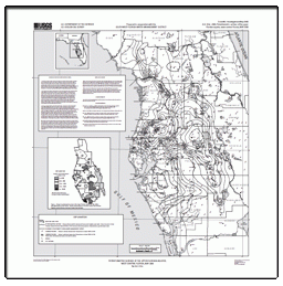
The Floridan aquifer system consists of the Upper and Lower Floridan aquifers separated by the middle confining unit. The middle confining unit and the Lower Floridan aquifer in west-central Florida generally contain highly mineralized water. The water-bearing units containing fresh water are herein referred to as the Upper Floridan aquifer. The Upper Floridan aquifer is the principal source of water in the Southwest Florida Water Management District and is used for major public supply, domestic use, irrigation, and brackish water desalination in coastal communities (Southwest Florida Water Management District, 2000).
This map report shows the potentiometric surface of the Upper Floridan aquifer measured in May 2009. The potentiometric surface is an imaginary surface connecting points of equal altitude to which water will rise in tightly-cased wells that tap a confined aquifer system (Lohman, 1979). This map represents water-level conditions near the end of the dry season, when ground-water levels usually are at an annual low and withdrawals for agricultural use typically are high. The cumulative average rainfall of 48.53 inches for west-central Florida (from June 2008 through May 2009) was 4.12 inches below the historical cumulative average of 52.65 inches (Southwest Florida Water Management District, 2009). Historical cumulative averages are calculated from regional rainfall summary reports (1915 to most recent complete calendar year) and are updated monthly by the Southwest Florida Water Management District.
This report, prepared by the U.S. Geological Survey in cooperation with the Southwest Florida Water Management District, is part of a semi-annual series of Upper Floridan aquifer potentiometric-surface map reports for west-central Florida. Potentiometric-surface maps have been prepared for January 1964, May 1969, May 1971, May 1973, May 1974, and for each May and September since 1975. Water-level data are collected in May and September each year to show the approximate annual low and high water-level conditions, respectively. Most of the water-level data for this map were collected by the U.S. Geological Survey during the period May 18-22, 2009. Supplemental water-level data were collected by other agencies and companies. A corresponding potentiometric-surface map was prepared for areas east and north of the Southwest Florida Water Management District boundary by the U.S. Geological Survey office in Orlando, Florida (Kinnaman and Dixon, 2009).
Most water-level measurements were made during a 5-day period; therefore, measurements do not represent a "snapshot" of conditions at a specific time, nor do they necessarily coincide with the seasonal low water-level condition. The potentiometric contours are generalized to synoptically portray the head in a dynamic hydrologic system, taking due account of the variations in hydrogeologic conditions, such as differing depths of wells, nonsimultaneous measurements of water levels, variable effects of pumping, and changing climatic influence. The potentiometric contours may not conform exactly with the individual measurements of water levels.
- Height In Inches
- 34.000
- Length In Inches
- 34.000
