


Product Details
- Product Number
- 249816
- Series
- SIM-3137
- Scale
- 1:100,000
- Alternate ID
- SIM3137
- ISBN
- 978-1-4113-3007-8
- Authors
- ROBERT G BOHANNON
- Version Date
- 01/01/2010
- Media
- Paper
- Format
- Folded
Additional Details
- Description
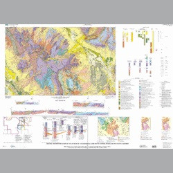
- This report consists of two map sheets, this pamphlet, and a collection of database files. Sheet 1 is the geologic map with three highly speculative cross sections, and sheet 2 is a topographic map that comprises all the support data for the geologic map. Both maps (sheets 1 and 2) are produced at 1:100,000-scale and are provided in Geospatial PDF format that preserves the georegistration and original layering. The database files include images of the topographic hillshade (shaded relief) and color-topography files used to create the topographic maps, a copy of the Landsat image, and a gray-scale basemap. Vector data from each of the layers that comprise both maps are provided in the form of Arc/INFO shapefiles. Most of the geologic interpretations and all of the topographic data were derived exclusively from images. A variety of image types were used, and each image type corresponds to a unique view of the geology. The geologic interpretations presented here are the result of comparing and contrasting between the various images and making the best uses of the strengths of each image type. A limited amount of fieldwork, in the spring of 2004 and the fall of 2006, was carried out within the quadrangle, but all the war-related dangers present in Afghanistan restricted its scope, duration, and utility. The maps that are included in this report represent works-in-progress in that they are simply intended to be the best possible product for the time available and conditions that exist during the early phases of reconstruction in Afghanistan. This report has been funded by the United States Agency for International Development (USAID) as a part of several broader programs that USAID designed to stimulate growth in the energy and mineral sectors of the Afghan economy. The main objective is to provide maps that will be used by scientists of the Afghan Ministry of Mines, the Afghanistan Geological Survey, and the Afghan Geodesy and Cartography Head Office in their efforts to rebuild the energy and mineral sectors of their economy.
- Survey Date
- 2010
- Print Date
- 2010
- Two Sided
- No
- Pieces
- 3
- Languages
- English
Related Items

Geologic and Topographic Maps of the Kabul North 30' x 60' Quadrangle, Afghanistan
Geologic and Topographic Maps of the Kabul North 30' x 60' Quadrangle, Afghanistan (CD version)
Geologic and Geophysical Maps of the Las Vegas 30'x60' Quadrangle, Clark and Nye Counties, Nevada, and Inyo County, California