GEOLOGIC MAPS OF LAS VEGAS QUADRANGLE

Product Details
- Product Number
- 205345
- Series
- SIM-2814
- Scale
- 1:100,000
- Alternate ID
- SIM2814
- ISBN
- 978-0-607-98075-2
- Authors
- WORKMAN JEREMIAH B
- Version Date
- 01/01/2005
- Regions
- CA
- Countries
- USA
- Media
- Paper
- Format
- Flat
- Digital Reproduction
- Yes
Additional Details
- Description
-
Abstract
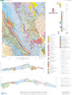
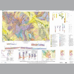
Las Vegas and Pahrump are two of the fastest growing cities in the US, and the shortage of water looms as among the greatest future problems for these cities. These new maps of the Las Vegas 30 x 60-minute quadrangle provide a geologic and geophysical framework and fundamental earth science database needed to address societal issues such as ground water supply and contamination, surface flood, landslide, and seismic hazards, and soil properties and their changing impact by and on urbanization.The mountain ranges surrounding Las Vegas and Pahrump consist of Mesozoic, Paleozoic and Proterozoic rocks. A majority of these rocks are Paleozoic carbonate rocks that are part of Nevada's carbonate rock aquifer province. The Spring Mountains represent a major recharge site in the province, where maximum altitude is 3,632 m (Charleston Peak) above sea level. Rocks in the Sheep and Las Vegas Ranges and Spring Mountains contain correlative, northeast-striking, southeast-verging thrust faults that are part of the Cretaceous, Sevier orogenic belt. These thrusts were offset during the Miocene by the Las Vegas Valley shear system (LVVSZ). We conducted new mapping in the Blue Diamond area, highlighting refined work on the Bird Spring thrust, newly studied ancient landslides, and gravity-slide blocks. We conducted new mapping in the Las Vegas Range and mapped previously unrecognized structures such as the Valley thrust and fold belt; recognition of these structures has led to a refined correlation of Mesozoic thrust faults across the LVVSZ. New contributions in the quadrangle also include a greatly refined stratigraphy of Paleozoic bedrock units based on conodont biostragraphy. We collected over 200 conodont samples in the quadrangle and established stratigraphic reference sections used to correlate units across the major Mesozoic thrust faults.Quaternary deposits cover about half of the map area and underlie most of the present urbanized area. Deposits consist of large coalescing alluvial fans that grade downslope to extensive areas of fine-grained sediment indicative of groundwater-discharge during the Pleistocene. In the central areas of Las Vegas and Pahrump valleys, Quaternary fault scarps associated with past ground-water discharge deposits suggest a genetic relationship. In collaboration with NBMG and University of Nevada, a variety of ages of gravelly alluvium are newly mapped using surficial characteristics and soil development, along with reassessment of previously published mapping during compilation. Reconnaissance geochronology (thermoluminescence and U-series) of eolian and authigenic components of surficial and buried soils and spring deposits is applied to test hypotheses of geomorphic and hydrologic response to climate change over the past 100 k.y.). The major structure in the Las Vegas quadrangle is the LVVSZ. Because the LVVSZ is concealed by thick basin-fill deposits of Quaternary and Tertiary age, it was characterized primarily based on geophysics. Likewise, the newly described State line fault system in Pahrump Valley has also been characterized by geophysics, where geophysically inferred structures correlate remarkably with surface structures defined by our new geologic mapping in the Mound Spring and Hidden Hills Ranch 7.5-minute quadrangles.
- Survey Date
- 2005
- Print Date
- 2005
- Height In Inches
- 40.000
- Length In Inches
- 55.000
- Boundary Type
- Political Unit
- Two Sided
- No
- Pieces
- 3
- Languages
- English