
EDWARDS AQUIFER NE KINNEY AND EDWARDS TX

Product Details
- Product Number
- 232848
- Series
- SIM-3105
- Scale
- 1:50,000
- Alternate ID
- SIM3105
- ISBN
- 978-1-4113-2663-7
- Authors
- DAVID W MOORE
- Version Date
- 01/01/2010
- Regions
- TX
- Countries
- USA
- Media
- Paper
- Format
- Folded
Additional Details
- Description
-
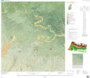
The Edwards aquifer is the most prolific carbonate aquifer in south-central Texas. It supplies water to agriculture, industry, military, natural ecosystems, and potable water to more than two million people in the region. Comanchean and Gulfian Series Cretaceous strata, consisting of the 200-m-thick Edwards aquifer and the confining rock units above and below it, dip gently and thicken southward (seaward) in northeastern Kinney and southernmost Edwards Counties. These shallow marine shelf carbonate strata total about 400 m in thickness and were divided into lithostratigraphic formations that were mapped at 1:24,000 scale in nine quadrangles and parts of three more.
Normal faults, mostly downdropped to the southeast, trend northeastward across the area. They lie within a western extension of the Balcones fault zone. Other structural features include a few broad, open folds and several solution collapse features. Basaltic igneous rock bosses and dikes intrude the limestone and mudstone strata, recording Late Cretaceous volcanism, perhaps in shallow seas. The northern part of the map area is the hilly Edwards Plateau cut by streams into resistant, Upper Cretaceous limestone. The plateau is bounded on the south by the Balcones Escarpment. The west Gulf Coastal Plain lies south of the escarpment.
The purpose of this report is to provide a detailed geologic map that can assist in the management of groundwater resources in Kinney County. Knowing the nature of the rock strata in the recharge and confined zones of the Edwards aquifer is necessary for understanding water volumes and flow in the aquifer.
- Survey Date
- 2005
- Print Date
- 2010
- Height In Inches
- 37.500
- Length In Inches
- 43.500
- Two Sided
- Yes
- Pieces
- 2
- Languages
- English

