
GEOLOGIC MAP EVANSVILLE HENDERSON, IN

Product Details
- Product Number
- 210862
- Series
- SIM-3069
- Scale
- 1:50,000
- Alternate ID
- SIM3069
- ISBN
- 978-1-4113-2402-2
- Authors
- WILLIAM ANDREWS JR M
- Version Date
- 01/01/2009
- Regions
- IN, KY
- Countries
- USA
- Media
- Paper
- Format
- Folded
Additional Details
- Description
-
Abstract
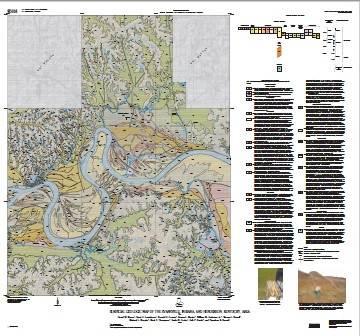
The geologic map of the Evansville, Indiana, and Henderson, Kentucky, area depicts and describes surficial deposits according to their origin and age. Unconsolidated alluvium and outwash fill the Ohio River bedrock valley and attain maximum thickness of 33-39 m under Diamond Island, Kentucky, and Griffith Slough, south of Newburgh, Indiana. The fill is chiefly unconsolidated, fine- to medium-grained, lithic quartz sand, interbedded with clay, clayey silt, silt, coarse sand, granules, and gravel. Generally, the valley fill fines upward from the buried bedrock surface: a lower part being gravelly sand to sandy gravel, a middle part mostly of sand, and a surficial veneer of silt and clay interspersed with sandy, natural levee deposits at river's edge. Beneath the unconsolidated fill are buried and discontinuous, lesser amounts of consolidated fill unconformably overlying the buried bedrock surface. Most of the glaciofluvial valley fill accumulated during the Wisconsin Episode (late Pleistocene). Other units depicted on the map include creek alluvium, slackwater lake (lacustrine) deposits, colluvium, dune sand, loess, and sparse bedrock outcrops. Creek alluvium underlies creek floodplains and consists of silt, clayey silt, and subordinate interbedded fine sand, granules, and pebbles. Lenses and beds of clay are present locally. Silty and clayey slackwater lake (lacustrine) deposits extensively underlie broad flats northeast of Evansville and around Henderson and are as thick as 28 m. Fossil wood collected from an auger hole in the lake and alluvial deposits of Little Creek, at depths of 10.6 m and 6.4 m, are dated 16,650+-50 and 11,120+-40 radiocarbon years, respectively. Fossil wood collected from lake sediment 16 m below the surface in lake sediment was dated 33,100+-590 radiocarbon years. Covering the hilly bedrock upland is loess (Qel), 3-7.5 m thick in Indiana and 9-15 m thick in Kentucky, deposited about 22,000-12,000 years before present. Most mapped surficial deposits in the quadrangle are probably no older than about 55,000 years. Lithologic logs, shear-wave velocities, and other cone penetrometer data are used to interpret depositional environments and geologic history of the surficial deposits. This map, which includes an area of slightly more than seven 7.5-minute quadrangles, serves several purposes. It is a tool for assessing seismic and flood hazards of a major urban area; aids urban planning; conveys geologic history; and locates aggregate resources. The map was produced concurrently with research by seismologists to determine places where the surficial deposits may tend to liquefy and (or) to amplify ground motions during strong earthquakes. Such hazardous responses to shaking are related to the characteristics of the geologic materials and topographic position, which the geologic map depicts. The geologic map is an element in the cooperative seismic hazard assessment program among the States of Indiana, Kentucky, and Illinois and the U.S. Geological Survey, funded by the National Earthquake Hazards Reduction Program and National Cooperative Geologic Mapping Program of the U.S. Geological Survey.
- Survey Date
- 2009
- Print Date
- 2009
- Height In Inches
- 39.000
- Length In Inches
- 41.000
- Boundary Type
- Quadrangle
- Two Sided
- Yes
- Pieces
- 2
- Languages
- English

