

Product Details
- Product Number
- 207910
- Series
- SIM-2987
- Scale
- MISCELLANEOUS
- Alternate ID
- SIM2987
- ISBN
- 978-1-4113-1999-8
- Authors
- AMY FOXGROVER C
- Version Date
- 01/01/2007
- Regions
- CA
- Countries
- USA
- Media
- Paper
- Format
- Flat
- Digital Reproduction
- Yes
Additional Details
- Description
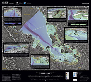
-
This map consists of a view of the southern end of San Francisco bay with the water 'removed.' The image is overlain by a set of six figures:
Figure 1. Perspective view looking southeast down south San Francisco Bay.
Figure 2. Perspective view looking east with the Diablo Range in the distance.
Figure 3. Perspective view looking southwest over Bair Island toward Redwood City.
Figure 4. Perspective view looking northwest over the Coyote Hills.
Figure 5. Perspective view looking north toward Newark Slough and the Coyote Hills.
Figure 6. Perspective view looking southeast toward Coyote Creek, Guadalupe Slough, and the Alviso Salt Ponds.
- Survey Date
- 2007
- Print Date
- 2007
- Height In Inches
- 33.000
- Length In Inches
- 37.000
- Boundary Type
- Geographic Unit
- Two Sided
- No
- Pieces
- 1
- Languages
- English
Related Items

Map of Quaternary-active Faults in the San Francisco Bay Region

Under the Golden Gate Bridge-Views of the Sea Floor near the entrance to San Francisco Bay, California
