

Product Details
- Product Number
- 206444
- Series
- SIM-2921
- Scale
- 1:24,000
- Alternate ID
- SIM2921
- Authors
- JOHN E REPETSKI
- Version Date
- 01/01/2006
- Regions
- AR
- Countries
- USA
- Media
- Paper
- Format
- Flat
- Digital Reproduction
- Yes
Additional Details
- Description
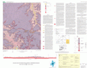
- This map summarizes the geology of the Western Grove 7.5-minute quadrangle in northern Arkansas that is located on the southern flank of the Ozark dome, a late Paleozoic regional uplift. The exposed bedrock of this map area comprises approximately 1,000 ft of Ordovician and Mississippian carbonate and clastic sedimentary rocks that have been mildly folded and broken by faults. A segment of the Buffalo River loops through the southern part of the quadrangle, and the river and adjacent lands form part of Buffalo National River, a park administered by the U.S. National Park Service. This geologic map provides information to better understand the natural resources of the Buffalo River watershed, particularly its karst hydrogeologic framework.
- Survey Date
- 2006
- Print Date
- 2006
- Height In Inches
- 34.380
- Length In Inches
- 43.750
- Boundary Type
- Quadrangle
- Two Sided
- No
- Languages
- English
Related Items

Geologic Map of the Boxley Quadrangle, Newton and Madison Counties, Arkansas

Geologic Map of the Maumee Quadrangle, Searcy and Marion Counties, Arkansas

Geologic map of the Hasty quadrangle, Boone and Newton Counties, Arkansas