

Product Details
- Product Number
- 208240
- Series
- SIM-2991
- Scale
- 1:24,000
- Alternate ID
- SIM2991
- Authors
- KENZIE J TURNER
- Version Date
- 01/01/2007
- Regions
- AR
- Countries
- USA
- Media
- Paper
- Format
- Flat
- Digital Reproduction
- Yes
Additional Details
- Description
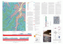
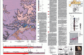
- This map summarizes the geology of the Boxley 7.5-minute quadrangle in the Ozark Plateaus region of northern Arkansas. Geologically, the area lies on the southern flank of the Ozark dome, an uplift that exposes oldest rocks at its center in Missouri. Physiographically, the Boxley quadrangle lies within the Boston Mountains, a high plateau region underlain by Pennsylvanian sandstones and shales. Valleys of the Buffalo River and its tributaries expose an approximately 1,600-ft-(490-m-)thick sequence of Ordovician, Mississippian, and Pennsylvanian carbonate and clastic sedimentary rocks that have been mildly deformed by a series of faults and folds. Part of Buffalo National River, a park encompassing the Buffalo River and adjacent land that is administered by the National Park Service, extends through the eastern part of the quadrangle.
- Print Date
- 2007
- Height In Inches
- 35.000
- Length In Inches
- 50.000
- Two Sided
- No
- Pieces
- 1
- Languages
- English
Related Items

Geologic map of the Hasty quadrangle, Boone and Newton Counties, Arkansas

Geologic Map of the Maumee Quadrangle, Searcy and Marion Counties, Arkansas
Geologic Map of the St. Joe Quadrangle, Searcy and Marion Counties, Arkansas