
GEOLOGIC SHENANDOAH NATIONAL PARK, VA

Product Details
- Product Number
- 116709
- Series
- OFR-2009-1153
- Scale
- NO SCALE
- Alternate ID
- 091153
- Authors
- WILLIAM C BURTON
- Version Date
- 01/01/2009
- Regions
- VA
- Countries
- USA
- Media
- Paper
- Format
- Flat
Additional Details
- Description
-
Abstract
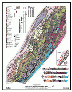
The geology of the Shenandoah National Park region of Virginia was studied from 1995 to 2008. The focus of the study was the park and surrounding areas to provide the National Park Service with modern geologic data for resource management. Additional geologic data of the adjacent areas are included to provide regional context. The geologic map can be used to support activities such as ecosystem delineation, land-use planning, soil mapping, groundwater availability and quality studies, aggregate resources assessment, and engineering and environmental studies.
The study area is centered on the Shenandoah National Park, which is mostly situated in the western part of the Blue Ridge province. The map covers the central section and western limb of the Blue Ridge-South Mountain anticlinorium. The Skyline Drive and Appalachian National Scenic Trail straddle the drainage divide of the Blue Ridge highlands. Water drains northwestward to the South Fork of the Shenandoah River and southeastward to the James and Rappahannock Rivers. East of the park, the Blue Ridge is an area of low relief similar to the physiography of the Piedmont province. The Great Valley section of the Valley and Ridge province is west of Blue Ridge and consists of Page Valley and Massanutten Mountain. The distribution and types of surficial deposits and landforms closely correspond to the different physiographic provinces and their respective bedrock.
The Shenandoah National Park is underlain by three general groups of rock units: (1) Mesoproterozoic granitic gneisses and granitoids, (2) Neoproterozoic metasedimentary rocks of the Swift Run Formation and metabasalt of the Catoctin Formation, and (3) siliciclastic rocks of the Lower Cambrian Chilhowee Group. The gneisses and granitoids mostly underlie the lowlands east of Blue Ridge but also rugged peaks like Old Rag Mountain (996 meter). Metabasalt underlies much of the highlands, like Stony Man (1,200 meters). The siliciclastic rocks underlie linear ridges from 800 to 400 meters in altitude. The Page Valley is underlain by Cambrian and Ordovician carbonate rocks. Siliciclastic rocks are mostly west of the South Fork of the Shenandoah River and underlie Massanutten Mountain. Surficial deposits in the highlands include colluvium and debris fans. The lowlands have broad alluvial fans, alluvial plains, and fluvial terraces. Ridges underlain by siliciclastic rocks have abundant boulder fields. Numerous sinkholes and caves are due to the dissolution of the carbonate bedrock.
- Height In Inches
- 50.000
- Length In Inches
- 39.000
- Two Sided
- No
- Pieces
- 2

