
MOUNT IDHABOD AREA, GEOLOGIC, NV

Geologic map of the Mount Ichabod area, Elko County, Nevada
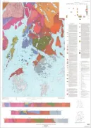
GEOLOGIC MAP OF RIO CAURA QUAD VENEZUELA
Geologic map of the Rio Caura 2 degrees x 3 degrees Quadrangle, Estado Bolivar and Estado Amazonas, Venezuela
GEOLOGIC MAP OF THE SCOTTSBLUFF QUAD, NE
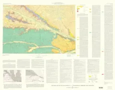
Geologic map of the Scottsbluff 1 degree by 2 degrees Quadrangle, Nebraska and Colorado
NORTHERN PENOBSCOT BAY-GEOL
Geology of northern Penobscot Bay, Maine
GULF OF CARPENTARIA
Bathymetric map of the Gulf of Carpentaria and the Arafura Sea
HUBBARD BROOK - BEDROCK GEOLOG, NH
Bedrock geologic map of Hubbard Brook Experimental Forest and maps of fractures and geology in roadcuts along Interstate 93, Grafton County, New Hampshire
ASHLAND/IRONWOOD (N'ERN), GEOL, WI
Bedrock geologic map of the Ashland and the northern part of the Ironwood 30- x 60-minute quadrangles, Wisconsin and Michigan
PLATTE AND GOSHEN COUNTIES, WY
Geologic map of Precambrian rocks along part of the Hartville Uplift, Guernsey and Casebier Hill quadrangles, Platte and Goshen counties, Wyoming
WABASH VALLEY - EARTHQUAKES, IL
Map showing earthquake intensities in the vicinity of the lower Wabash Valley, Illinois, Indiana, and Kentucky
WABASH VALLEY - SELECTED WELLS, IL
Map showing selected wells and geophysical survey and modeling lines in the vicinity of the lower Wabash Valley, Illinois, Indiana, and Kentucky
WABASH VALLEY - SEISMOTECTONIC, IL
Seismotectonic map showing faults, igneous rocks, and geophysical and neotectonic features in the vicinity of the lower Wabash Valley, Illinois, Indiana, and Kentucky
SW BALOCHISTAN
Satellite image map S.W. Balochistan, Pakistan
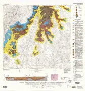
JEFF DAVIS PEAK, GEOLOGIC MAP, MT
Geologic map of the Jeff Davis Peak Quadrangle and the eastern part of the Everson Creek Quadrangle, Beaverhead County, southwest Montana
GEOLOGIC MAP OF GALINDO QUAD, V-40 VENUS
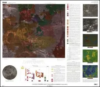
Geologic/geomorphic map of the Galindo Quadrangle (V-40), Venus
MADISON COUNTY, FLOOD, 6/27/95, VA
Map of rainfall, debris flows, and flood effects of the June 27, 1995, storm in Madison County, Virginia