
TOPOGRAPHIC CEBRENIA QUADRANGLE MARS
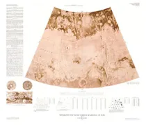
Topographic map of the Cebrenia Quadrangle of Mars
KANSAS CITY - LAND USE/COVER, MO

Land use and land cover, Kansas City, Missouri; Kansas, 1973
COKEVILLE, GEOLOGIC &STRUCTURE, WY
Geologic map and structure sections of the Cokeville 30-minute Quadrangle, Lincoln and Sublette counties Wyoming
TOPOGRAPHIC MAP ELYSIUM QUADRANGLE MARS
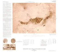
Topographic map of the Elysium Quadrangle of Mars
RUBY MOUNTAINS, GEOLOGIC MAP, NV
Geologic map of the Ruby Mountains, Nevada
UINTA BASIN SE - VEGETATION, UT
Vegetation map of the southeastern Uinta Basin, Utah and Colorado
GEOLOGIC YAUCO PUNTA VERRACO, PR
Geologic map of the Yauco and Punta Verraco quadrangles, Puerto Rico
SEWARD/BLYING SOUND, GEOLOGIC, AK
Geologic map of the Seward and Blying Sound quadrangles, Alaska
GEOLOGIC MAP CAGUAS PUERTO RICO, PR
Geologic map of the Caguas Quadrangle, Puerto Rico
KENTUCKY, UPPER ORDOV NOMENCLA, KY
Lithofacies and stratigraphic nomenclature of part of the Upper Ordovician section of Kentucky
TOPOGRAPHIC THAUMASIA QUADRANGLE MARS
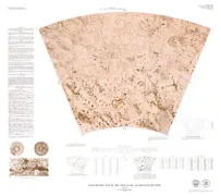
Topographic map of the Thaumasia Quadrangle of Mars
TWIN CITIES AREA, GEOL & HYDRO, MN
Geologic and hydrologic aspects of tunneling in the Twin Cities area, Minnesota
MERCURY RELIEF ALBEDO MARKINGS MARINER
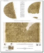
Mercury relief and albedo markings visible on Mariner 10 images
THOMAS RANGE/NORTHERN DRUM MOUNTAINS, UT
Geologic map and cross sections of Tertiary rocks in the Thomas Range and northern Drum Mountains, Juab County, Utah
MARYSVILLE DISTRICT - URANIUM, UT
Uranium in the central mining area, Marysvale District, west-central Utah