

Product Details
- Product Number
- 27125
- Series
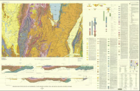
- I-1129
- Scale
- 1:62,500
- Alternate ID
- GI1129D
- ISBN
- 978-0-607-78151-9
- Authors
- ORIEL, S. S.
- Version Date
- 01/01/1980
- Regions
- WY
- Countries
- USA
- Media
- Paper
- Format
- Folded
Additional Details
- Description
- 2 SHEETS
- Survey Date
- 1980
- Print Date
- 1980
- Boundary Type
- Quadrangle
- Two Sided
- No
- Pieces
- 1
- Languages
- English
Related Items

Geologic map and structure sections along part of the lower Yukon River, Alaska
Geologic map of the Kemmerer 30' x 60' Quadrangle, Lincoln, Uinta, and Sweetwater counties, Wyoming
Geologic map of the Logan 30' x 60' Quadrangle, Cache and Rich counties, Utah, and Lincoln and Uinta counties, Wyoming