
RECONNAISSANCE GEOLOGIC PENDLETON, OR

Reconnaissance geologic map of the Pendleton Quadrangle, Oregon and Washington
RECONNAISSANCE GEOLOGIC NABESNA A-2, AK
Reconnaissance geologic map of the Nabesna A-2 Quadrangle, Alaska
GARLOCK FAULT, ACTIVE BREAKS, CA
Map showing recently active breaks along the Garlock and associated faults, California
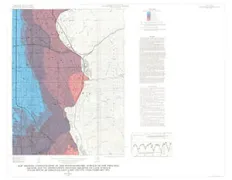
GEOLOGIC MAP BAYAMON QUADRANGLE, PR
Geologic map of the Bayamon Quadrangle, Puerto Rico
LANDSLIDE DEPOSITS SUGAR HOUSE QUAD, UT
Landslide and associated deposits map of the Sugar House Quadrangle, Salt Lake County, Utah
BEDROCK TOPOGRAPHY CURDSVILLE, KY
Map showing bedrock topography and subcrop of selected beds beneath alluvial deposits of the Curdsville Quadrangle, western Kentucky
SUGAR HOUSE, PRINICIPAL AQUIFE, UT
Map showing depth to top of the principal aquifer, Sugar House Quadrangle, Salt Lake County, Utah, February l972
SUGAR HOUSE, POTENTIOMETRIC, UT
Map showing configuration of the potentiometric surface of the principal aquifer and its approximate position relative to land surface, Sugar House Quadrangle, Salt Lake County, Utah, February 1972
KNOW COUNTY, SEDIMENTARY ROCKS, TN
Distribution of sedimentary rocks in Knox County, Tennessee
KNOX COUNTY, SINKHOLE AREAS, TN
Areas with abundant sinkholes in Knox County, Tennessee
KNOX COUNTY, ENG CHAR OF OVERB, TN
Engineering characteristics of overburden in Knox County, Tennessee
PARKER - SWELLING POTENTIAL, CO
Map showing relative swelling-pressure potential of geologic materials in the Parker Quadrangle, Arapahoe and Douglas counties, Colorado
PARKER - PIONEER TRAILS, CO
Map of pioneer trails, stage stops, and areas with a view in the Parker Quadrangle, Arapahoe and Douglas counties, Colorado
PARKER - VEGETATION, CO
Vegetation map of the Parker Quadrangle, Arapahoe and Douglas counties, Colorado
VOINJAMA, AREOMAGNETIC MAP
Aeromagnetic map of the Voinjama Quadrangle, Liberia