
- Added CARTHAGE WEST, IL to cart. View cart.
- Added SHOHOLA, PA-NY to cart. View cart.
- Added DYERSBURG, TN HISTORICAL MAP GEOPDF 7.5X to cart. View cart.
- Added AFTON, WY to cart. View cart.
- Added PEPIN, WI-MN HISTORICAL MAP GEOPDF 7.5X7 to cart. View cart.
- Added CENTERVILLE, WA to cart. View cart.
- Added CINCINNATI, OH-IN-KY HISTORICAL MAP GEOP to cart. View cart.


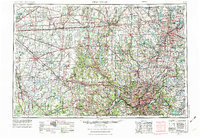
Product Details
- Product Number
- 267305
- Scale
- 1:250,000
- Version Date
- 01/01/1953
- Regions
- IN, KY, OH
- Countries
- USA
- Media
- Paper
- Format
- Flat
Additional Details
- Description
- CINCINNATI, OH-IN-KY HISTORICAL MAP GEOPDF 1X2 GRID 250000-SCALE 1953
- Survey Date
- 1953
- Print Date
- 1976
- Height In Inches
- 22.200
- Length In Inches
- 32.100
- Boundary Type
- Quadrangle
- Pieces
- 1
Related Items

CINCINNATI, OH-IN-KY HISTORICAL MAP GEOPDF 1X2 GRID 250000-SCALE 1953