
- Added RUTH LAKE, CA HISTORICAL MAP GEOPDF 7.5X to cart. View cart.
- Added WEST OF VENTANA, AZ to cart. View cart.
- Added CONTROLLED PHOTOMOSAIC DIACRIA SW MARS to cart. View cart.
- Added TRINCHERA PEAK, CO to cart. View cart.
- Added WHITE HILLS WEST, AZ to cart. View cart.
- Added RUTH LAKE, CA to cart. View cart.
- Added CONTROLLED MOSAIC IAPYGIA NE QUAD MARS to cart. View cart.
- Added TRINCHERA, CO to cart. View cart.
- Added PORT LEYDEN, NY to cart. View cart.
- Added CLARKSVILLE, FL HISTORICAL MAP GEOPDF 7. to cart. View cart.
- Added MOUNT COEUR D'ALENE, ID to cart. View cart.
- Added COTTONWOOD CAMP, TX to cart. View cart.
- Added STRAWBERRY VALLEY, CA to cart. View cart.
- Added HILLSVILLE, VA-NC HISTORICAL MAP GEOPDF to cart. View cart.
- Added WOODSTOCK, VA-WV HISTORICAL MAP GEOPDF 3 to cart. View cart.
- Added SPRINGER LAKE, NM to cart. View cart.
- Added WAVERLY, OH HISTORICAL MAP GEOPDF 15X15 to cart. View cart.


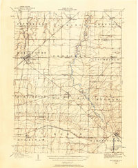
Product Details
- Product Number
- 266788
- Scale
- 1:62,500
- Version Date
- 01/01/1904
- Regions
- OH
- Countries
- USA
- Media
- Paper
- Format
- Flat
Additional Details
- Description
- WESTERVILLE, OH HISTORICAL MAP GEOPDF 15X15 GRID 62500-SCALE 1904
- Survey Date
- 1902
- Print Date
- 1941
- Height In Inches
- 19.800
- Length In Inches
- 16.500
- Boundary Type
- Quadrangle
- Pieces
- 1
Related Items
WELLINGTON, OH HISTORICAL MAP GEOPDF 15X15 GRID 62500-SCALE 1904
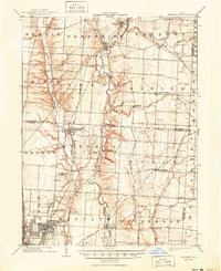
WESTERVILLE, OH HISTORICAL MAP GEOPDF 15X15 GRID 62500-SCALE 1904
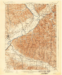
WAVERLY, OH HISTORICAL MAP GEOPDF 15X15 GRID 62500-SCALE 1908