- Added MACHIAS BAY, ME to cart. View cart.
- Added SAVAGE, MD to cart. View cart.
- Added GW RES KINGS & QUEENS CNTIES L, NY to cart. View cart.
- Added HARMONY, ME to cart. View cart.
- Added THOLEIITIC BASALT, 1965 MAKAOPUHI LAVA to cart. View cart.
- Added NEPONSET AND WYMOUTH RIVER BAS, MA to cart. View cart.
- Added PEAKED MOUNTAIN POND, ME to cart. View cart.
- Added STEPHENTOWN CENTER, NY to cart. View cart.
- Added MOUNT GRACE, MA-NH to cart. View cart.
- Added LIMERICK, ME to cart. View cart.
- Added TOMAH MOUNTAIN, ME to cart. View cart.
- Added ROCKY BROOK, ME to cart. View cart.
- Added NORTH FORK AMERICAN RIVER WATERSHED, CA to cart. View cart.
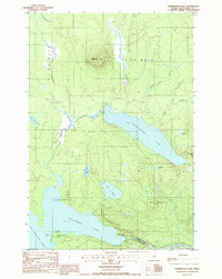
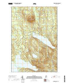
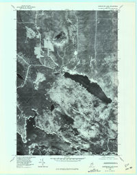
- Added HARRINGTON LAKE, ME HISTORICAL MAP GEOPD to cart. View cart.
Product Details
- Product Number
- 312871
- Scale
- 1:24,000
- Version Date
- 01/01/1978
- Regions
- ME
- Countries
- USA
- Media
- Paper
- Format
- Flat
Additional Details
- Description
- HARRINGTON LAKE, ME HISTORICAL MAP GEOPDF 7.5X7.5 GRID 24000-SCALE 1978
- Survey Date
- 1978
- Print Date
- 1981
- Height In Inches
- 27.500
- Length In Inches
- 21.600
- Boundary Type
- Quadrangle
- Pieces
- 1
Related Items