- Added HUTCHINSON, KS to cart. View cart.
- Added LEOTI, KS to cart. View cart.
- Added GRINDSTONE CREEK, KS to cart. View cart.
- Added DODGE CITY, KS to cart. View cart.
- Added HANOVER, VA to cart. View cart.
- Added HAMMOND, KS to cart. View cart.
- Added MANNING, KS to cart. View cart.
- Added DORRANCE NW, KS HISTORICAL MAP GEOPDF 7. to cart. View cart.
- Added GEORGETOWN, KY to cart. View cart.
- Added WOODBINE, KS to cart. View cart.
- Added TURKEY CREEK, KS to cart. View cart.
- Added KINSLEY, KS HISTORICAL MAP GEOPDF 7.5X7. to cart. View cart.
- Added OSAGE CITY SE, KS to cart. View cart.
- Added SAFFORDVILLE, KS HISTORICAL MAP GEOPDF 7 to cart. View cart.
- Added WESTFALL NW, KS to cart. View cart.
- Added WALTERVILLE, OR to cart. View cart.
- Added OBERLIN SW, KS to cart. View cart.
- Added RUSSELL SPRINGS, KS HISTORICAL MAP GEOPD to cart. View cart.
- Added LEXINGTON WEST, KY to cart. View cart.
- Added WEBBER, KS to cart. View cart.
- Added RUSH CENTER, KS to cart. View cart.
- Added DATA FROM USGS STREAMGAGING ST, US to cart. View cart.
- Added MITCHELL COUNTY, KS to cart. View cart.
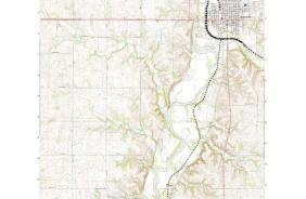
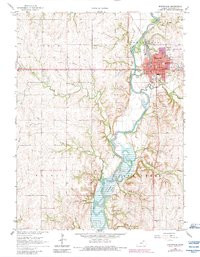
- Added 
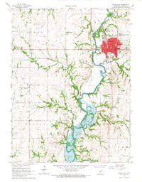
MARYSVILLE, KS HISTORICAL MAP GEOPDF 7.5 to cart. View cart.
Product Details
- Product Number
- 59152
- Scale
- 1:24,000
- Alternate ID
- TKS0847
- ISBN
- 978-0-607-21039-2
- Version Date
- 01/01/1983
- Regions
- KS
- Countries
- USA
- Media
- Paper
- Format
- Flat
- Digital Reproduction
- Yes
Additional Details
- Description
- PR83
- Survey Date
- 1966
- Print Date
- 1983
- Height In Inches
- 27.000
- Length In Inches
- 21.000
- Boundary Type
- Quadrangle
- Two Sided
- No
- Pieces
- 1
- Languages
- English
Related Items