- Added VECTOR MAP LEVEL 1 AREA 206 to cart. View cart.
- Added DORIS, WA to cart. View cart.
- Added KODIAK A-5, AK to cart. View cart.
- Added WASHINGTON COUNTY, KS to cart. View cart.
- Added AMHERST, WI to cart. View cart.
- Added LAKE FRYXELL, ANTARCTICA to cart. View cart.
- Added LOWER VACHERIE, LA HISTORICAL MAP GEOPDF to cart. View cart.
- Added TIGERTOWN, TX to cart. View cart.
- Added CONTROLLED PHOTOMOSAIC OF CALLISTO to cart. View cart.
- Added HATTIESBURG L-92, US to cart. View cart.
- Added GAMBIER, OH HISTORICAL MAP GEOPDF 15X15 to cart. View cart.
- Added PORT MOLLER A-6, AK to cart. View cart.
- Added SEISMIC-HAZARD MAPS CA, NV, AZ, UT MAP B to cart. View cart.
- Added THOMASTON, GA to cart. View cart.
- Added KRACHEN, CAMBODIA to cart. View cart.
- Added GRANVILLE, OH to cart. View cart.


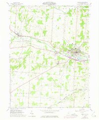
Product Details
- Product Number
- 898327
- Scale
- 1:24,000
- Version Date
- 01/01/1961
- Regions
- OH
- Countries
- USA
- Media
- Paper
- Format
- Flat
- Digital Reproduction
- Yes
Additional Details
- Description
- GRANVILLE, OH HISTORICAL MAP GEOPDF 7.5X7.5 GRID 24000-SCALE 1961
- Survey Date
- 1961
- Print Date
- 1975
- Boundary Type
- Quadrangle
- Pieces
- 1
Related Items