
- Added FREEPORT WEST, IL to cart. View cart.
- Added BARABOO, WI HISTORICAL MAP GEOPDF 7.5X7. to cart. View cart.
- Added TERRELL WELLS, TX to cart. View cart.
- Added SCHROEDER MOUNTAIN, NV to cart. View cart.
- Added LAS VEGAS DE LOS LADRONES, TX to cart. View cart.
- Added PINEVILLE, WV HISTORICAL MAP GEOPDF 15X1 to cart. View cart.
- Added BAT CAVE, NC to cart. View cart.
- Added LAS VEGAS DE LOS LADRONES SW, TX to cart. View cart.
- Added HUNTSVILLE, AL HISTORICAL MAP GEOPDF 7.5 to cart. View cart.
- Added CLEVELAND, TN HISTORICAL MAP GEOPDF 30X3 to cart. View cart.
- Added ROCK DAM LAKE, WI to cart. View cart.
- Added PANGUITCH, UT to cart. View cart.
- Added FLYING H, NM to cart. View cart.
- Added PEORIA, IL HISTORICAL MAP GEOPDF 1X2 GRI to cart. View cart.
- Added ELECTRIC CITY, WA to cart. View cart.
- Added SCRANTON, KY to cart. View cart.
- Added MONROE, MI to cart. View cart.
- Added SHINYANGA, TANZANIA to cart. View cart.
- Added RAMONA, SD to cart. View cart.
- Added ASPEN GROVE, UT to cart. View cart.
- Added HILDRETH PEAK, CA to cart. View cart.
- Added RUSSELLVILLE, AR HISTORICAL MAP GEOPDF 1 to cart. View cart.
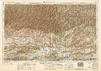

Product Details
- Product Number
- 839881
- Scale
- 1:250,000
- Version Date
- 01/01/1956
- Regions
- AR
- Countries
- USA
- Media
- Paper
- Format
- Flat
- Digital Reproduction
- Yes
Additional Details
- Description
- RUSSELLVILLE, AR HISTORICAL MAP GEOPDF 1X2 GRID 250000-SCALE 1956
- Survey Date
- 1956
- Print Date
- 1956
- Boundary Type
- Quadrangle
- Pieces
- 1
Related Items

RUSSELLVILLE, AR HISTORICAL MAP GEOPDF 1X2 GRID 250000-SCALE 1964
RUSSELLVILLE, AR HISTORICAL MAP GEOPDF 1X2 GRID 250000-SCALE 1977
RUSSELLVILLE, AR HISTORICAL MAP GEOPDF 1X2 GRID 250000-SCALE 1992