- Added BINFIELD, TN HISTORICAL MAP GEOPDF 7.5X7 to cart. View cart.
- Added WOLFEBORO, NH HISTORICAL MAP GEOPDF 15X1 to cart. View cart.
- Added SAINT XAVIER, MT-WY HISTORICAL MAP GEOPD to cart. View cart.
- Added SAINT REGIS, MT-ID HISTORICAL MAP GEOPDF to cart. View cart.
- Added STRATFORD HALL, VA-MD HISTORICAL MAP GEO to cart. View cart.
- Added RANDOLPH, WI to cart. View cart.
- Added HAROLD, FL to cart. View cart.
- Added SPRING LICK, KY to cart. View cart.
- Added BISHOP, CA to cart. View cart.
- Added WEST LAKE, FL to cart. View cart.
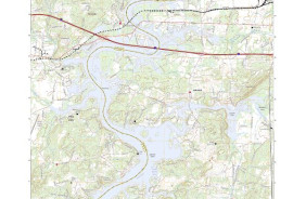
- Added RIVERSIDE, AL HISTORICAL MAP GEOPDF 7.5X to cart. View cart.


Product Details
- Product Number
- 311485
- Scale
- 1:24,000
- Version Date
- 01/01/1947
- Regions
- AL
- Countries
- USA
- Media
- Paper
- Format
- Flat
Additional Details
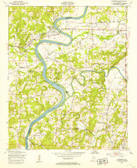
- Description
- RIVERSIDE, AL HISTORICAL MAP GEOPDF 7.5X7.5 GRID 24000-SCALE 1947
- Survey Date
- 1947
- Print Date
- 1953
- Height In Inches
- 26.700
- Length In Inches
- 21.900
- Boundary Type
- Quadrangle
- Pieces
- 1
Related Items

RIVERSIDE, AL HISTORICAL MAP GEOPDF 7.5X7.5 GRID 24000-SCALE 1947