
- Added RICHMOND, VA to cart. View cart.
- Added PECOS, NM to cart. View cart.
- Added HOUCK, AZ to cart. View cart.
- Added NASHVILLE EAST, TN to cart. View cart.
- Added EAGLES MERE, PA to cart. View cart.
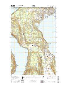
- Added TENINO, WA HISTORICAL MAP GEOPDF 15X15 G to cart. View cart.
- Added BADGER MOUNTAIN, WA to cart. View cart.
- Added BADGER GAP, WA to cart. View cart.
- Added CHERITON, VA to cart. View cart.
- Added CUMERO CANYON, AZ to cart. View cart.
- Added CAMERON SOUTH, AZ HISTORICAL MAP GEOPDF to cart. View cart.
- Added NASHVILLE EAST, TN HISTORICAL MAP GEOPDF to cart. View cart.
- Added PORT TOWNSEND SOUTH, WA to cart. View cart.
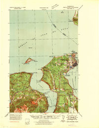

Product Details
- Product Number
- 924410
- Scale
- 1:62,500
- Version Date
- 01/01/1939
- Regions
- WA
- Countries
- USA
- Media
- Paper
- Format
- Flat
- Digital Reproduction
- Yes
Additional Details
- Description
- PORT TOWNSEND, WA HISTORICAL MAP GEOPDF 15X15 GRID 62500-SCALE 1939
- Survey Date
- 1939
- Print Date
- 1939
- Boundary Type
- Quadrangle
- Pieces
- 1
Related Items
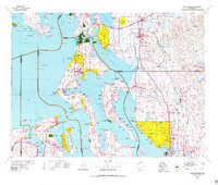
PORT TOWNSEND, WA HISTORICAL MAP GEOPDF 30X60 GRID 100000-SCALE 1975
