
- Added WATERLOO, CA to cart. View cart.
- Added SAWIK MOUNTAIN, AZ to cart. View cart.
- Added STUART, VA to cart. View cart.
- Added LAKE LOUISA, FL to cart. View cart.
- Added DRAKE PEAK, OR to cart. View cart.
- Added NORTH POWNAL, VT-NY HISTORICAL MAP GEOPD to cart. View cart.
- Added MEDIMONT, ID to cart. View cart.
- Added HIGLEY, AZ HISTORICAL MAP GEOPDF 7.5X7.5 to cart. View cart.
- Added SUMNER, WA to cart. View cart.
- Added HOPE POND, TX to cart. View cart.
- Added WISCONSIN RAPIDS, WI HISTORICAL MAP GEOP to cart. View cart.
- Added EDNA MOUNTAIN, MT to cart. View cart.
- Added SALMON BUTTE, ID to cart. View cart.
- Added FOUNTAIN RUN, KY-TN to cart. View cart.
- Added PADDOCK VALLEY RESERVOIR, ID to cart. View cart.
- Added CANOE, KY to cart. View cart.
- Added HOPE, TX to cart. View cart.
- Added SCRANTON, NC to cart. View cart.
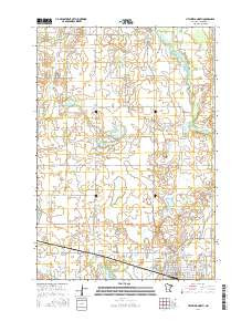
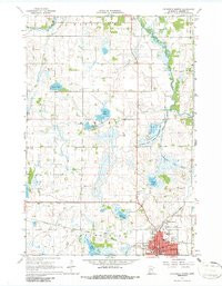
- Added LITCHFIELD NORTH, MN to cart. View cart.


Product Details
- Product Number
- 272058
- Scale
- 1:24,000
- Version Date
- 01/01/1967
- Regions
- MN
- Countries
- USA
- Media
- Paper
- Format
- Flat
Additional Details
- Description
- LITCHFIELD NORTH, MN HISTORICAL MAP GEOPDF 7.5X7.5 GRID 24000-SCALE 1967
- Survey Date
- 1967
- Print Date
- 1968
- Height In Inches
- 27.200
- Length In Inches
- 21.200
- Boundary Type
- Quadrangle
- Pieces
- 1
Related Items

LITCHFIELD NORTH, MN HISTORICAL MAP GEOPDF 7.5X7.5 GRID 24000-SCALE 1967