- Added ONAWA, IA HISTORICAL MAP GEOPDF 7.5X7.5 to cart. View cart.
- Added BRANDON, SD-IA to cart. View cart.
- Added PRIMGHAR, IA HISTORICAL MAP GEOPDF 7.5X7 to cart. View cart.
- Added KEOTA, IA HISTORICAL MAP GEOPDF 7.5X7.5 to cart. View cart.
- Added SCOTLAND, GA TNM GEOSPATIAL PDF 7.5X7.5 to cart. View cart.
- Added ORIENT, IA to cart. View cart.
- Added RHODES, IA to cart. View cart.
- Added RELATION OF LAND USE TO NITRAT, MN to cart. View cart.
- Added OLAF, IA to cart. View cart.
- Added NEW LONDON, AR to cart. View cart.
- Added OELWEIN, IA HISTORICAL MAP GEOPDF 7.5X7. to cart. View cart.
- Added LAMONT, IA to cart. View cart.

Product Details
- Product Number
- 53459
- Scale
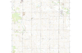
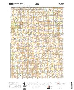
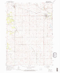
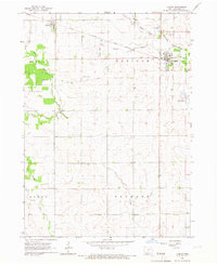
- 1:24,000
- Alternate ID
- TIA0526
- ISBN
- 978-0-607-16172-4
- Version Date
- 01/01/1965
- Regions
- IA
- Countries
- USA
- Media
- Paper
- Format
- Flat
- Digital Reproduction
- Yes
Additional Details
- Description
- LAMONT, IA HISTORICAL MAP GEOPDF 7.5X7.5 GRID 24000-SCALE 1965
- Survey Date
- 1965
- Print Date
- 1967
- Height In Inches
- 27.000
- Length In Inches
- 22.000
- Boundary Type
- Quadrangle
- Two Sided
- No
- Pieces
- 1
- Languages
- English
Related Items
LAMONT, IA HISTORICAL MAP GEOPDF 7.5X7.5 GRID 24000-SCALE 1965