
Product Details
- Product Number
- 61865
- Scale
- 1:24,000
- Alternate ID
- TLA0416
- ISBN
- 978-0-607-97475-1
- Version Date
- 01/01/1972
- Regions
- LA, MS
- Countries
- USA
- Media
- Paper
- Format
- Flat
- Digital Reproduction
- Yes
Additional Details
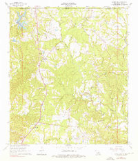
- Description
- LAUREL HILL, LA-MS HISTORICAL MAP GEOPDF 7.5X7.5 GRID 24000-SCALE 1965
- Survey Date
- 2005
- Print Date
- 1976
- Height In Inches
- 26.700
- Length In Inches
- 22.900
- Boundary Type
- Quadrangle
- Two Sided
- No
- Pieces
- 1
- Languages
- English
Related Items